 Printable Scholar
Plate Tectonics and Earthquakes
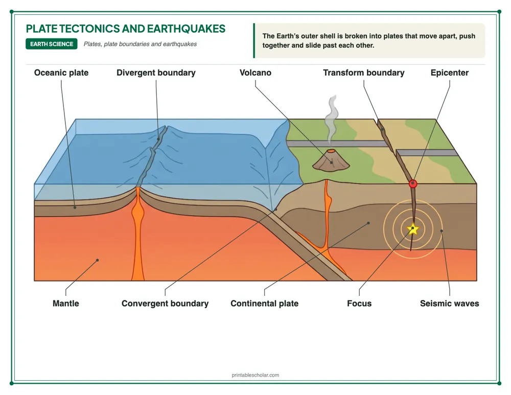
Free printable plate tectonics diagram: the three kinds of plate boundary (divergent, convergent and transform), oceanic and continental plates, the mantle, and an earthquake's focus, epicenter and seismic waves, labeled, plus a blank diagram to label. PDF or PNG for Letter paper.
Part of the Plate Tectonics and Earthquakes teaching pack for grades 5 to 8: 25 lesson slides and 8 printables with answer keys. The diagram and the blank one to label are free.
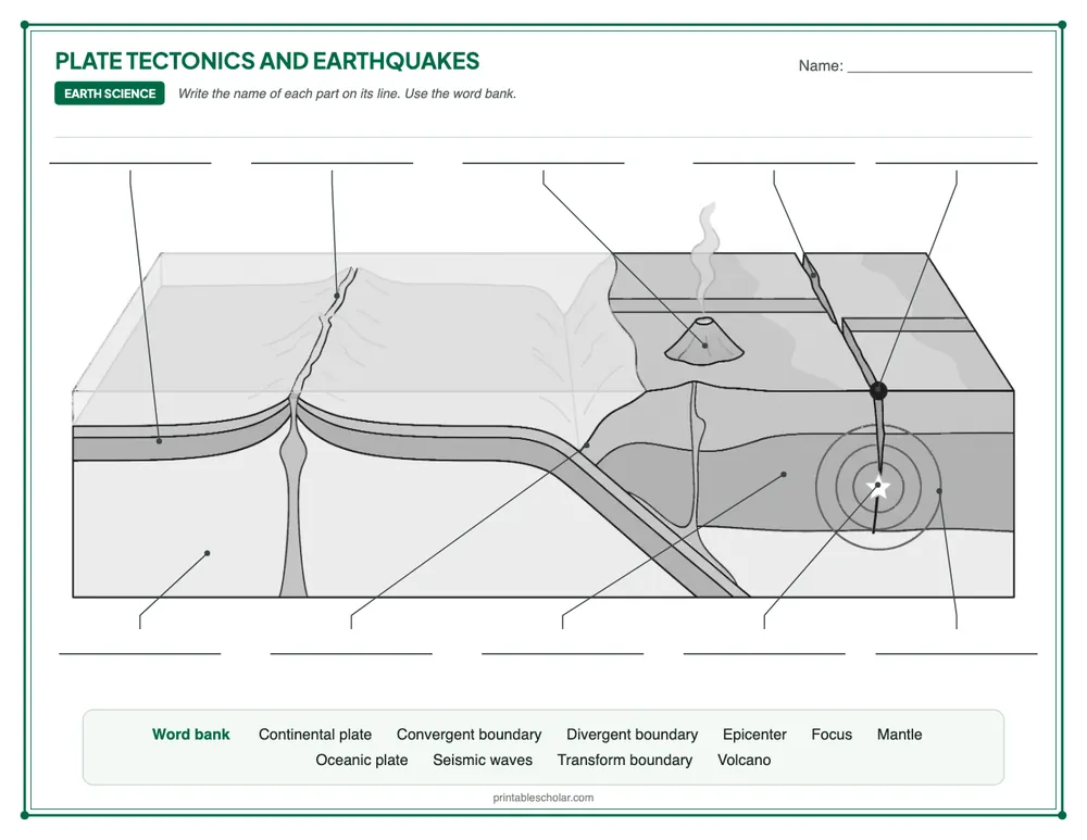
Blank diagram to label
Download blank version + answer key 10 blanks, a word bank, and the answer key on page 2Teaching ideas for Plate Tectonics and Earthquakes
Pick the ideas that suit your class, then follow the plan or use the sheets in any order.
- Cracked eggshell. Bring in a hard-boiled egg and gently crack its shell all over. The pieces fit together like the Earth’s plates, which rest on the softer rock below.
- Hands as plates. Students put their palms together and push, pull them apart, then slide them past each other. Name each move: convergent, divergent and transform.
- Find them on a map. Show a world map of the plates. Students find the Andes, the Himalayas, Iceland and the San Andreas Fault and say which kind of boundary each one is on.
A plan for the week
| Day 1 | Open with one of the ideas above. Teach the lesson with the slides while students fill in the guided notes. Then students label the blank diagram. | Lesson slides (PowerPoint) (in the pack) Plate Tectonics and Earthquakes Guided Notes (in the pack) Plate Tectonics and Earthquakes Diagram Blank Plate Tectonics and Earthquakes |
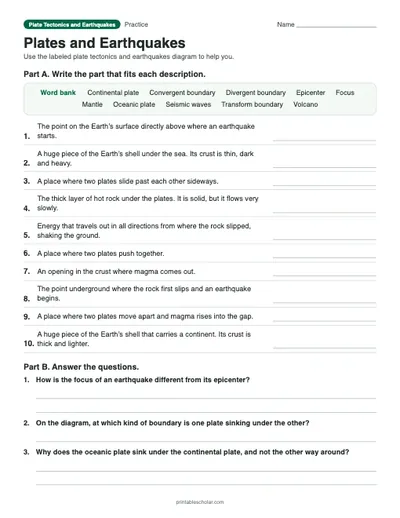
| Day 2 | Students match each part of the diagram to its description on “Plates and Earthquakes” and answer the questions. | Plates and Earthquakes (in the pack) |
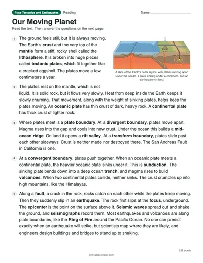
| Day 3 | Read “Our Moving Planet” and answer the questions. | Our Moving Planet (in the pack) |
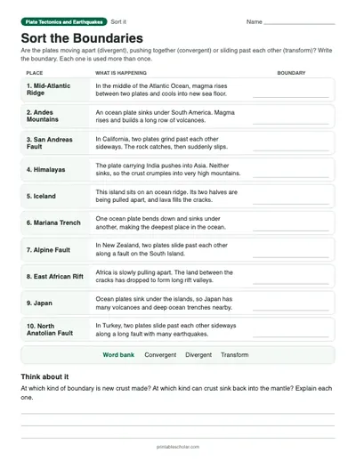
| Day 4 | Students read what is happening in ten places on “Sort the Boundaries” and sort each one into divergent, convergent or transform. | Sort the Boundaries (in the pack) |
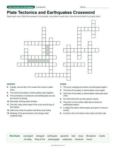
| Day 5 | Review with the crossword, then give the quiz. | Plate Tectonics and Earthquakes Crossword (in the pack) Plate Tectonics and Earthquakes Quiz (in the pack) |
The sheets marked “in the pack” are in the Plate Tectonics and Earthquakes teaching pack below.
NGSS standards
- Supports MS-ESS2-2: Construct an explanation based on evidence for how geoscience processes have changed Earth's surface at varying time and spatial scales.
- Supports MS-ESS2-3: Analyze and interpret data on the distribution of fossils and rocks, continental shapes, and seafloor structures to provide evidence of the past plate motions.
- Supports MS-ESS3-2: Analyze and interpret data on natural hazards to forecast future catastrophic events and inform the development of technologies to mitigate their effects.
Plate Tectonics and Earthquakes teaching pack
Teaching plate tectonics and earthquakes? This pack has ready-made lesson slides and 8 printables that cover how the Earth’s plates move and what happens where they meet, in teaching order, with every answer key.
Free on this page: 2 of the 9 printables, marked Download below. The whole pack is $7: 18 pages in one print-ready file, the 25 lesson slides, the practice sheets, the crossword, the quiz and every answer key.
OnlineThe pack also comes as an online lesson for Google Classroom: every part on screen for students, plus a self-grading Google Forms quiz.
One-time purchase. Instant download. Secure checkout by Stripe. Want to see a whole pack first? The Cells pack is free.See all 14 packs in the bundle
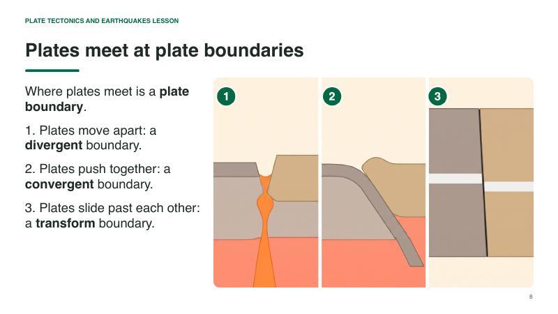
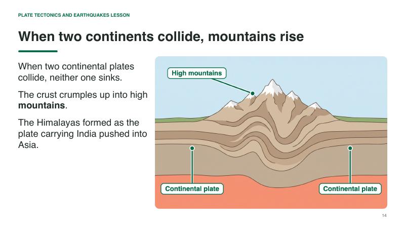
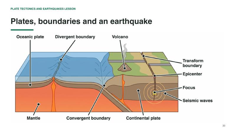
Teach Plate Tectonics and Earthquakes with 25 ready-made slides
Open the PowerPoint and teach: an opening question, the parts one at a time on the diagram, quick checks and an exit question. Your notes for each slide are in the speaker notes. Students fill in the guided notes sheet as you go.
The slides (PowerPoint and a PDF copy) and the guided notes sheet come with the pack.What is in the pack, in teaching order
 In the pack
1. TeachLesson Slides25 slides to present, with your notes for each one.In the $7 pack
 In the pack
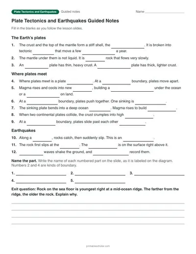
1. TeachPlate Tectonics and Earthquakes Guided NotesStudents fill in the blanks as you present. With answer key.In the $7 pack
 Free
 Free
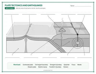
2. LabelBlank Plate Tectonics and EarthquakesStudents label 10 parts from a word bank.Download free PDF
 In the pack
3. MatchPlates and EarthquakesMatch the 10 parts of the diagram to their descriptions, then answer three questions.In the $7 pack
 In the pack
4. ReadOur Moving PlanetA one-page text on how the Earth’s plates move, what happens at their boundaries and what causes earthquakes, with eight questions.In the $7 pack
 In the pack
5. SortSort the BoundariesRead about ten real places and sort each one by the kind of plate boundary it is on.In the $7 pack
 In the pack
6. ReviewPlate Tectonics and Earthquakes CrosswordFourteen plate tectonics and earthquake words with clues and a word bank.In the $7 pack
 In the pack
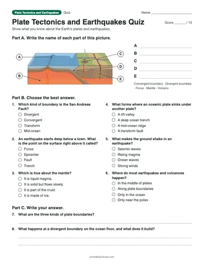
7. CheckPlate Tectonics and Earthquakes QuizLabel five parts, six multiple choice and two written answers. Scored out of 13.In the $7 pack
Plate Tectonics and Earthquakes worksheets, crossword and quiz
The Plate Tectonics and Earthquakes teaching pack is 25 lesson slides (PowerPoint and PDF) and 8 printables with answer keys for grades 5 to 8, in the order you would teach them: the guided notes for the lesson slides, the labeled diagram and the blank one to label, then “Plates and Earthquakes” (a worksheet), “Our Moving Planet” (a reading passage), “Sort the Boundaries” (a sorting table), a vocabulary crossword and a quiz.
The sheets are in a suggested teaching order: teach the lesson, have students label the blank diagram, then work through the practice sheets and finish with the quiz. Use them all over a week or pick the ones you need. The answer keys are together at the back.
The diagram and the blank one to label are free to download on this page. The other sheets come with the pack ($7), which is also in the Middle School Science bundle (grades 5 to 8).
The crust and the very top of the mantle form a stiff, rocky shell called the lithosphere. It is broken into about a dozen large tectonic plates and many smaller ones, which fit together like the pieces of a cracked eggshell. The plates rest on hotter, softer rock in the mantle below, and they move very slowly, usually a few centimeters (about an inch or two) a year, and up to about 15 centimeters (6 inches) a year at the fastest. Most of the action happens at the edges, called plate boundaries. Where plates move apart (a divergent boundary), magma rises and makes new crust. Where they push together (a convergent boundary), one plate can sink under the other, making deep ocean trenches and volcanoes, or the crust crumples up into mountains. Where they slide past each other (a transform boundary), the rock catches and then suddenly slips. A crack in the rock where this happens is called a fault, and the sudden slip is an earthquake. Most earthquakes and volcanoes happen along plate boundaries.
Plates, plate boundaries and earthquakes
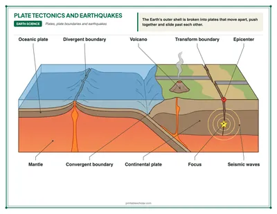
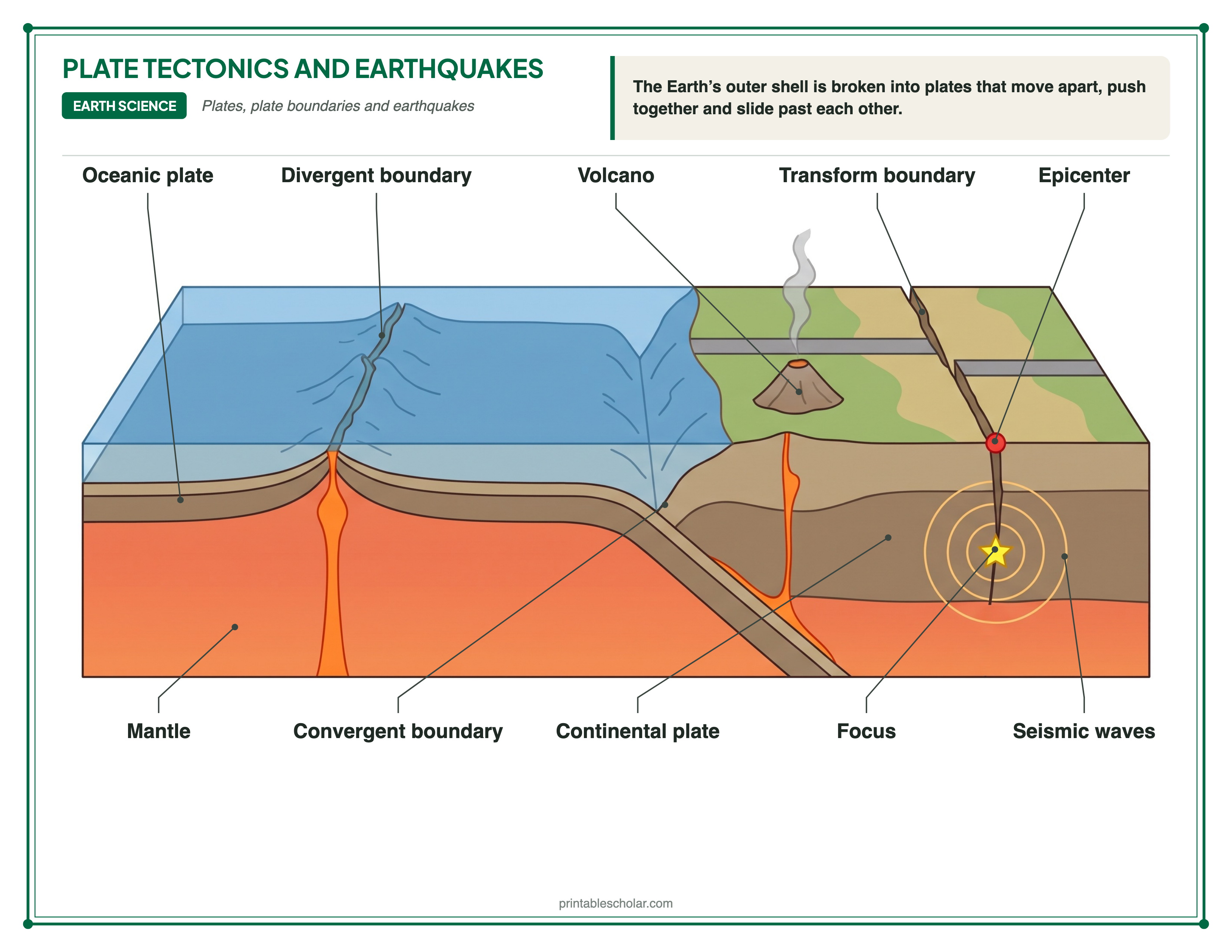
The Earth’s rocky outer shell is broken into huge pieces called tectonic plates. They move a few centimeters a year, and where they meet they make mountains, volcanoes and earthquakes. Here is what happens at each labeled part of the diagram:
| Part | What it does | Why it matters |
|---|---|---|
| Oceanic plate | A plate that lies under the ocean. Its crust is thin, made of dark, heavy rock. | Ocean crust is only about 5 to 10 kilometers (3 to 6 miles) thick, but it is denser than the crust of the continents. That is why an oceanic plate sinks when it runs into a continental plate. |
| Continental plate | A plate that carries a continent. Its crust is thick and made of lighter rock. | Continental crust is about 30 to 50 kilometers (20 to 30 miles) thick on average, and even thicker under big mountains. It is too light to sink into the mantle, so the oldest rocks on Earth are found on the continents. |
| Mantle | The thick layer of hot rock under the plates. It is solid, but it flows very slowly. | The plates rest on a hot, soft layer at the top of the mantle. Heat from deep inside the Earth keeps the mantle rock slowly churning, and that slow movement, along with the weight of sinking plates, helps keep the plates moving. |
| Divergent boundary | A place where two plates move apart. Magma rises into the gap and cools into new crust. | Most divergent boundaries are on the ocean floor, where they build long underwater mountain chains called mid-ocean ridges. The Mid-Atlantic Ridge runs down the middle of the Atlantic Ocean and even rises above the sea in Iceland. On land, plates moving apart open a rift valley, like the East African Rift. |
| Convergent boundary | A place where two plates push together. Here the heavier oceanic plate sinks under the continental plate. | Where one plate sinks under another, it bends down into a deep ocean trench. The Mariana Trench, the deepest place in the ocean, formed this way. When two continental plates collide, neither one sinks, and the crust crumples up into high mountains like the Himalayas. |
| Transform boundary | A place where two plates slide past each other sideways. | Crust is not made or destroyed at a transform boundary. The plates catch on each other, then suddenly slip, so these boundaries have many earthquakes. The San Andreas Fault in California is a transform boundary. |
| Volcano | An opening in the crust where magma comes out. A row of volcanoes often forms above a sinking plate. | As an oceanic plate sinks into the hot mantle, water from it helps the rock above to melt. The magma rises and erupts. The Ring of Fire, a horseshoe of volcanoes and earthquakes around the Pacific Ocean, mostly follows the edges of sinking plates. |
| Focus | The point underground where the rock first breaks or slips and an earthquake begins. | The focus is also called the hypocenter. Most earthquakes start in the top few tens of kilometers of the Earth, but some, where a plate is sinking, start hundreds of kilometers down. |
| Epicenter | The point on the Earth’s surface directly above the focus. | When the news reports where an earthquake happened, it gives the epicenter. The shaking is usually strongest near it. |
| Seismic waves | Waves of energy that spread out in all directions from the focus and make the ground shake. | Instruments called seismographs record seismic waves. The fastest waves, called P waves, arrive first, then S waves. Waves that travel along the surface usually cause the most damage. |
How to print
Choose Download PDF for a ready-to-print file that fits US Letter paper (8.5 × 11") in landscape, or Download PNG for the high-resolution image.
Frequently asked questions
What are the three types of plate boundaries?
Divergent boundaries, where plates move apart; convergent boundaries, where plates push together; and transform boundaries, where plates slide past each other sideways.
What is the difference between the focus and the epicenter of an earthquake?
The focus is the point underground where the rock first breaks or slips. The epicenter is the point on the surface directly above the focus.
What causes earthquakes?
Most earthquakes happen when rocks along a fault, often at a plate boundary, catch on each other while the plates keep moving, then suddenly slip. The energy spreads out as seismic waves that shake the ground.
What paper size should I print this on?
The diagram is sized for standard US Letter paper (8.5 × 11") in landscape orientation. Use "Download PDF" for a print-ready file that fits the page automatically.
Are there Plate Tectonics and Earthquakes worksheets to go with the diagram?
Yes. The Plate Tectonics and Earthquakes teaching pack, for grades 5 to 8, has 25 lesson slides and 8 printables with answer keys: the guided notes for the lesson slides, the labeled diagram and the blank one to label, then “Plates and Earthquakes” (a worksheet), “Our Moving Planet” (a reading passage), “Sort the Boundaries” (a sorting table), a vocabulary crossword and a quiz. The diagram and the blank one to label are free to download on this page. The other sheets come with the pack ($7), which is also in the Middle School Science bundle (grades 5 to 8).
Related: See where the plates and their boundaries are on our free tectonic plate map, then plot real volcanoes and earthquakes on the free Ring of Fire map worksheet.