Mexico Map with Cities
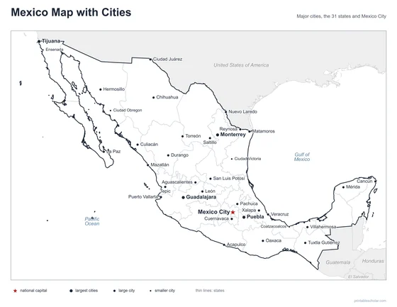
A free printable map of Mexico with its major cities: Mexico City, Guadalajara, Monterrey and 33 more. The capital is starred and the 31 states and Mexico City are outlined. It comes labeled and blank.

Choose your version
Labeled or blank.
Both are free PDFs sized for US Letter paper.
Labeled
Cities named, the capital starred, neighboring countries in gray.
downloadLabeled PDF
Blank
The same outline and city dots with no names, for labeling practice.
downloadBlank PDFThe cities of Mexico
Mexico lies between the United States to the north and Guatemala and Belize to the south, with the Pacific Ocean on the west and the Gulf of Mexico on the east. Mexico City, the capital, is on a high plateau in the center of the country and is one of the largest cities in the world. Guadalajara is to the west and Monterrey to the north. Tijuana and Ciudad Juárez are on the United States border. Cancún and Mérida are on the Yucatán Peninsula, and the long, narrow Baja California peninsula runs down the Pacific side.
The 36 cities on the map
- Guadalajara, Monterrey, Puebla, Tijuana, Mexico City, León, Ciudad Juárez, Mérida, Chihuahua, Acapulco, Hermosillo, Veracruz, Cancún, Oaxaca, Mazatlán, La Paz, Puerto Vallarta, Torreón, San Luis Potosí, Aguascalientes, Cuernavaca, Culiacán, Saltillo, Matamoros, Reynosa, Tuxtla Gutiérrez, Durango, Xalapa, Villahermosa, Nuevo Laredo, Pachuca, Tepic, Ciudad Obregon, Coatzacoalcos, Ciudad Victoria, Ensenada
Find it on the map
- Mexico City, the capital, in the central highlands
- Tijuana and Ciudad Juárez on the northern border
- Cancún at the tip of the Yucatán Peninsula
Boundaries and city locations are from Natural Earth. Dot sizes show roughly how large each city is.