Mexico Physical Map
A free printable physical map of Mexico, with elevation shown in color and shaded relief. The labeled version names the mountain ranges, deserts, plains, rivers, seas and highest peaks, plus the capital and largest cities. The blank version leaves them off for students to fill in.
Highest Point
Pico de Orizaba
18,491 ft
Lowest Point
Laguna Salada
about 33 ft below sea level

Choose your version
Labeled or blank.
Both are free PDFs sized for US Letter paper.
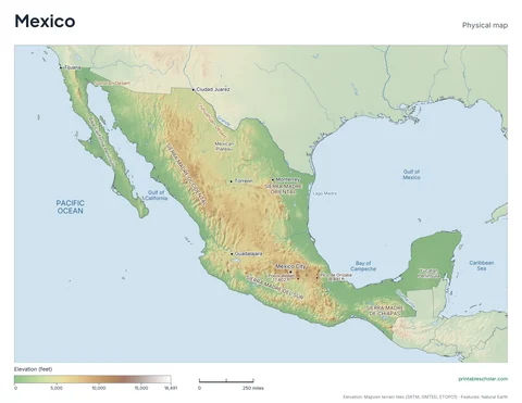
Labeled
Ranges, deserts, plains, rivers, lakes, seas and the highest peaks, all named. Use it as a reference or an answer key.
downloadLabeled PDF
Blank
The same terrain with no names and a name line at the top, for students to label the features themselves.
downloadBlank PDFThe physical geography of Mexico
Two mountain ranges run down the sides of Mexico: the Sierra Madre Occidental in the west and the Sierra Madre Oriental in the east. Between them is the Mexican Plateau, a high tableland that covers much of the north and center. A belt of volcanoes crosses the country at the plateau’s southern edge and includes Pico de Orizaba, the highest peak. Baja California is a long, narrow peninsula in the northwest, and the low, flat Yucatan Peninsula reaches into the Gulf of Mexico in the southeast.
Major rivers
- Rio Grande (Río Bravo)
- Lerma
- Balsas
- Grijalva
- Usumacinta
- Pánuco
Find it on the map
- Baja California, the long peninsula in the northwest
- The high plateau between the two Sierra Madre ranges
- The flat Yucatan Peninsula
Built from real data, not stock images.
The terrain is drawn from a global elevation model (Mapzen terrain tiles, built from NASA SRTM and other public surveys). Coastlines, rivers, lakes and feature names come from Natural Earth. The colors are spread over this country’s own elevation range, so its terrain shows clearly whether it is flat or mountainous.
Read full methodology arrow_forward