France Map with Cities
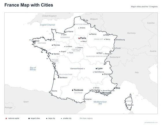
A free printable map of France with its major cities: Paris, Lyon, Marseille and 31 more. The capital is starred and the 13 regions are outlined. It comes labeled and blank.

Choose your version
Labeled or blank.
Both are free PDFs sized for US Letter paper.
Labeled
Cities named, the capital starred, neighboring countries in gray.
downloadLabeled PDF
Blank
The same outline and city dots with no names, for labeling practice.
downloadBlank PDFThe cities of France
France is the largest country in western Europe, with coasts on the English Channel, the Atlantic Ocean and the Mediterranean Sea. Paris, the capital and by far the largest city, is in the north on the Seine River. Lyon is in the east, on the Rhône. Marseille and Nice are on the Mediterranean coast, and Toulouse and Bordeaux are in the southwest. Lille is near Belgium, and Strasbourg is on the Rhine at the German border. The island of Corsica, in the Mediterranean, is also part of France.
The 34 cities on the map
- Lyon, Marseille, Nice, Toulouse, Paris, Lille, Bordeaux, Strasbourg, Nantes, Grenoble, Montpellier, Le Havre, Rennes, Reims, Dijon, Brest, Ajaccio, Metz, Nancy, Saint-Étienne, Melun, Tours, Clermont-Ferrand, Orléans, Mulhouse, Caen, Angers, Nîmes, Aix-en-Provence, Perpignan, Biarritz, Le Mans, Amiens, Besançon
Find it on the map
- Paris, the capital, in the north
- Marseille and Nice on the Mediterranean coast
- Strasbourg on the border with Germany
The overseas departments are not shown. Boundaries and city locations are from Natural Earth. Dot sizes show roughly how large each city is.