Printable Scholar
China Map with Cities
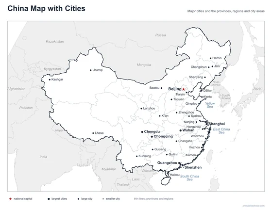
A free printable map of China with its major cities: Beijing, Shanghai, Guangzhou and 31 more. The capital is starred and the provinces and regions are outlined. It comes labeled and blank.

Choose your version
Labeled or blank.
Both are free PDFs sized for US Letter paper.
Labeled
Cities named, the capital starred, neighboring countries in gray.
downloadLabeled PDF
Blank
The same outline and city dots with no names, for labeling practice.
downloadBlank PDFThe cities of China
China is in East Asia and is one of the largest countries in the world, with more people than any country except India. Most people live in the east, where the land is lower and wetter and the big rivers reach the sea. Beijing, the capital, is in the north. Shanghai, the largest city, is on the coast where the Yangtze River meets the sea. Guangzhou and Shenzhen are in the south, near Hong Kong. Chongqing and Chengdu are in the Sichuan Basin in the southwest. The far west is high and dry: Lhasa is on the Tibetan Plateau, and Urumqi and Kashgar are in the deserts and oases of Xinjiang.
The 34 cities on the map
- Shanghai, Guangzhou, Shenzhen, Wuhan, Chongqing, Chengdu, Beijing, Tianjin, Shenyang, Xi’an, Nanjing, Harbin, Urumqi, Dalian, Hangzhou, Kunming, Qingdao, Lanzhou, Xiamen, Haikou, Guilin, Kashgar, Lhasa, Guiyang, Changchun, Taiyuan, Zhengzhou, Fuzhou, Changsha, Jilin, Wenzhou, Yantai, Baotou, Suzhou
Find it on the map
- Beijing, the capital, in the north
- Shanghai, the largest city, where the Yangtze reaches the sea
- Urumqi, Kashgar and Lhasa, far apart in the dry, high west
The small islands of the South China Sea are not shown. Boundaries and city locations are from Natural Earth. Dot sizes show roughly how large each city is.