Australia Map with Cities
A free printable map of Australia with its major cities: Canberra, Sydney, Melbourne and 27 more. The capital is starred and the states and territories are outlined. It comes labeled and blank.

Choose your version
Labeled or blank.
Both are free PDFs sized for US Letter paper.
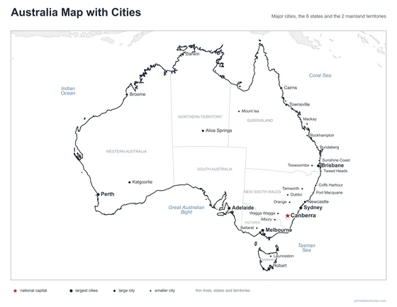
Labeled
Cities named, the capital starred, neighboring countries in gray.
downloadLabeled PDF
Blank
The same outline and city dots with no names, for labeling practice.
downloadBlank PDFThe cities of Australia
Australia is both a country and a continent. Most of its people live near the coast, especially in the southeast, because much of the interior is desert. Sydney and Melbourne are the two largest cities. Canberra, the capital, lies between them and was built to be the capital. Brisbane is on the east coast to the north, Adelaide on the south coast, and Perth far away on the west coast. Darwin is in the tropical north, and Hobart is on the island of Tasmania.
The 30 cities on the map
- Sydney, Melbourne, Brisbane, Perth, Adelaide, Canberra, Newcastle, Cairns, Townsville, Darwin, Hobart, Kalgoorlie, Alice Springs, Broome, Albury, Toowoomba, Ballarat, Mackay, Launceston, Sunshine Coast, Rockhampton, Coffs Harbour, Wagga Wagga, Bundaberg, Port Macquarie, Orange, Tamworth, Mount Isa, Tweed Heads, Dubbo
Find it on the map
- Canberra, the capital, between Sydney and Melbourne
- Perth, alone on the west coast
- Alice Springs, near the center of the continent
Boundaries and city locations are from Natural Earth. Dot sizes show roughly how large each city is.