Printable Scholar
Brazil Map with Cities
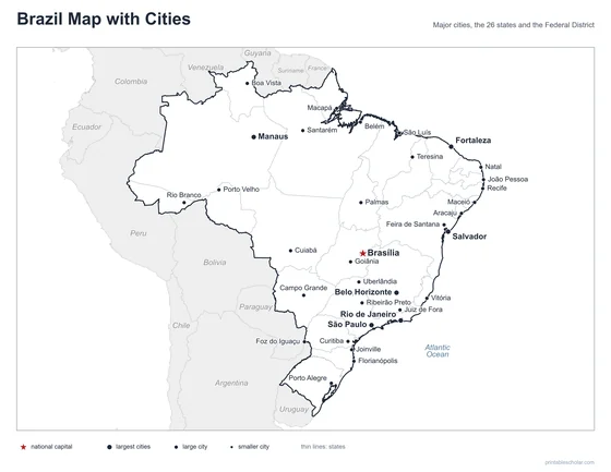
A free printable map of Brazil with its major cities: Brasília, São Paulo, Rio de Janeiro and 31 more. The capital is starred and the 27 states are outlined. It comes labeled and blank.

Choose your version
Labeled or blank.
Both are free PDFs sized for US Letter paper.
Labeled
Cities named, the capital starred, neighboring countries in gray.
downloadLabeled PDF
Blank
The same outline and city dots with no names, for labeling practice.
downloadBlank PDFThe cities of Brazil
Brazil is the largest country in South America and covers almost half of the continent. The Amazon rain forest fills the north, and very few people live there, so its cities, such as Manaus and Belém, are far apart along the rivers. Most Brazilians live near the Atlantic coast in the east and southeast. São Paulo is the largest city, and Rio de Janeiro is famous for its beaches and mountains. Salvador, Recife and Fortaleza are on the northeast coast. Brasília, the capital, was built in the middle of the country and opened in 1960.
The 34 cities on the map
- São Paulo, Rio de Janeiro, Belo Horizonte, Fortaleza, Salvador, Manaus, Brasília, Porto Alegre, Recife, Curitiba, Belém, Goiânia, Natal, São Luís, Florianópolis, Teresina, Cuiabá, Campo Grande, Macapá, Foz do Iguaçu, Porto Velho, Rio Branco, Palmas, Boa Vista, Santarém, Vitória, Maceió, Joinville, João Pessoa, Aracaju, Uberlândia, Ribeirão Preto, Feira de Santana, Juiz de Fora
Find it on the map
- Brasília, the capital, in the center of the country
- São Paulo and Rio de Janeiro in the southeast
- Manaus, deep in the Amazon rain forest
Small far islands such as Fernando de Noronha are not shown. Boundaries and city locations are from Natural Earth. Dot sizes show roughly how large each city is.