Spain Map with Cities
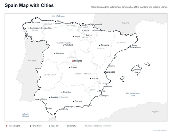
A free printable map of Spain with its major cities: Madrid, Barcelona, Seville and 31 more. The capital is starred and the autonomous communities are outlined. It comes labeled and blank.

Choose your version
Labeled or blank.
Both are free PDFs sized for US Letter paper.
Labeled
Cities named, the capital starred, neighboring countries in gray.
downloadLabeled PDF
Blank
The same outline and city dots with no names, for labeling practice.
downloadBlank PDFThe cities of Spain
Spain covers most of the Iberian Peninsula in southwestern Europe, which it shares with Portugal. Madrid, the capital, is almost exactly in the center of the country on a high plateau. Barcelona and Valencia are on the Mediterranean coast in the east. Seville, Córdoba, Granada and Málaga are in Andalusia in the south. Bilbao is on the north coast, on the Bay of Biscay. The Pyrenees mountains form the border with France.
The 34 cities on the map
- Barcelona, Seville, Valencia, Madrid, Bilbao, Zaragoza, Málaga, Murcia, Palma, Valladolid, Córdoba, Alicante, Santiago de Compostela, Toledo, Granada, Vigo, A Coruña, San Sebastián, Gijón, Cádiz, Pamplona, Oviedo, Vitoria, Santander, Cartagena, Marbella, Mataró, Castello, Almería, Burgos, Salamanca, Albacete, Huelva, Logroño
Find it on the map
- Madrid, the capital, in the center
- Barcelona and Valencia on the Mediterranean coast
- Palma, on the island of Mallorca
The Canary Islands, Ceuta and Melilla are not shown. Boundaries and city locations are from Natural Earth. Dot sizes show roughly how large each city is.