Japan Map with Cities
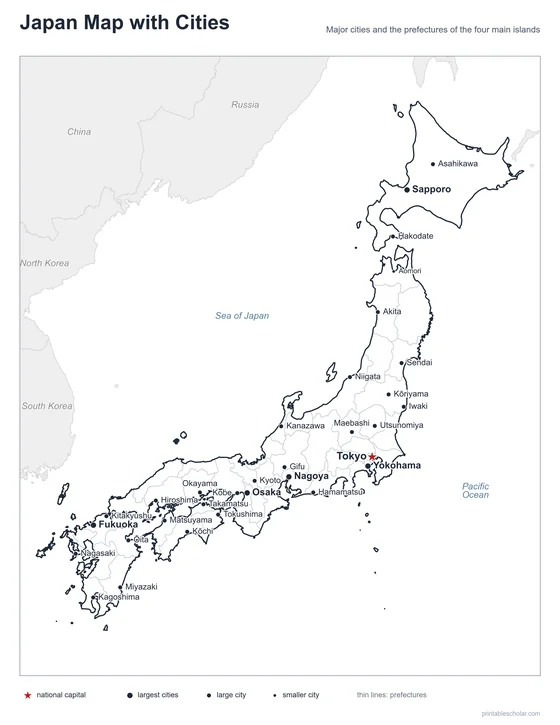
A free printable map of Japan with its major cities: Tokyo, Osaka, Yokohama and 29 more. The capital is starred and the prefectures are outlined. It comes labeled and blank.

Choose your version
Labeled or blank.
Both are free PDFs sized for US Letter paper.
Labeled
Cities named, the capital starred, neighboring countries in gray.
downloadLabeled PDF
Blank
The same outline and city dots with no names, for labeling practice.
downloadBlank PDFThe cities of Japan
Japan is a chain of islands off the east coast of Asia. Its four main islands, from north to south, are Hokkaido, Honshu, Shikoku and Kyushu. Honshu is the largest and holds most of the big cities. Tokyo, the capital, is on its Pacific coast, with Yokohama next to it. Nagoya, Kyoto, Osaka and Kobe lie to the west along the same coast. Sapporo is the main city of Hokkaido in the north, and Fukuoka is the largest city on Kyushu in the south.
The 32 cities on the map
- Osaka, Yokohama, Nagoya, Fukuoka, Sapporo, Tokyo, Sendai, Hiroshima, Kyoto, Kobe, Niigata, Kagoshima, Kanazawa, Nagasaki, Kitakyushu, Hamamatsu, Okayama, Utsunomiya, Matsuyama, Ōita, Tokushima, Gifu, Iwaki, Asahikawa, Maebashi, Kōriyama, Kōchi, Takamatsu, Miyazaki, Akita, Hakodate, Aomori
Find it on the map
- Tokyo, the capital, on the Pacific coast of Honshu
- Osaka, Kyoto and Kobe close together in the west
- Sapporo on the northern island of Hokkaido
Okinawa and the smaller southern islands are not shown. Boundaries and city locations are from Natural Earth. Dot sizes show roughly how large each city is.