Printable Scholar
Egypt Map with Cities
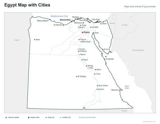
A free printable map of Egypt with its major cities: Cairo, Alexandria, Ismailia and 27 more. The capital is starred and the 27 governorates are outlined. It comes labeled and blank.

Choose your version
Labeled or blank.
Both are free PDFs sized for US Letter paper.
Labeled
Cities named, the capital starred, neighboring countries in gray.
downloadLabeled PDF
Blank
The same outline and city dots with no names, for labeling practice.
downloadBlank PDFThe cities of Egypt
Egypt is in the northeast corner of Africa, with the Sinai Peninsula reaching into Asia. Almost all of Egypt is desert, so nearly everyone lives along the Nile River and in its delta, where the river fans out before reaching the Mediterranean Sea. Cairo, the capital and largest city, is where the valley meets the delta. Alexandria is on the Mediterranean coast. Luxor and Aswan are in the Nile Valley to the south. Port Said, Ismailia and Suez are on the Suez Canal, and a few oasis towns such as Siwa lie in the Western Desert.
The 30 cities on the map
- Alexandria, Cairo, Ismailia, Port Said, Luxor, Suez, Asyut, Tanta, Aswan, Rosetta, El Arish, Hurghada, Marsa Matruh, El Kharga, El Tur, Siwa, El Alamein, Berenice, Mansoura, Sohag, El Minya, Beni Suef, Faiyum, Kom Ombo, Qena, Damietta, Zagazig, Mallawi, Samalut, Girga
Find it on the map
- Cairo, the capital, where the Nile Valley meets the delta
- Port Said, Ismailia and Suez along the Suez Canal
- Siwa, an oasis town in the Western Desert
Boundaries and city locations are from Natural Earth. Dot sizes show roughly how large each city is.