Western Europe Map
Free printable maps of Western Europe: a labeled map of its 24 countries, a blank outline map, and a physical map in labeled and blank versions.
Definitions of Western Europe vary. This map uses a broad one that includes the Nordic countries and the countries of southern Europe.

Choose your version
Four maps of Western Europe.
All free PDFs sized for US Letter paper.

Labeled
Every country named. Small countries are numbered with a key.
downloadLabeled PDF
Blank
Country outlines only, with a name line, for quizzes and coloring.
downloadBlank PDF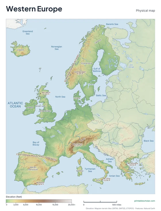
Physical
Shaded relief with mountains, deserts, rivers and peaks named.
downloadPhysical PDF
Physical, blank
The same terrain with no names, for labeling practice.
downloadBlank physical PDFThe geography of Western Europe
Western Europe is a land of peninsulas and islands, and no part of it is far from the sea. The Alps cross its center, with Mont Blanc the highest peak, and the Pyrenees separate Spain from France. The north is lowland: the plains of France, the Low Countries and northern Germany. Scandinavia has old, worn mountains and a coast cut by deep fjords. The British Isles and Iceland lie in the Atlantic, and Italy and Greece reach into the Mediterranean.
Countries on this map
- Andorra
- Austria
- Belgium
- Denmark
- Finland
- France
- Germany
- Greece
- Iceland
- Ireland
- Italy
- Liechtenstein
- Luxembourg
- Malta
- Monaco
- Netherlands
- Norway
- Portugal
- San Marino
- Spain
- Sweden
- Switzerland
- United Kingdom
- Vatican City
Major rivers
- Rhine
- Danube
- Loire
- Seine
- Rhône
- Tagus
- Thames
- Po
Find it on the map
- The Alps across the center
- The Scandinavian Peninsula in the north
- The boot shape of Italy
Built from real data, not stock images.
Country borders, coastlines, rivers and feature names come from Natural Earth. The terrain on the physical maps is drawn from a global elevation model built from NASA SRTM and other public surveys.
Read full methodology arrow_forward