East Asia Map
Free printable maps of East Asia: a labeled map of its 6 countries, a blank outline map, and a physical map in labeled and blank versions.
East Asia is China, Mongolia, North Korea, South Korea, Japan and Taiwan.

Choose your version
Four maps of East Asia.
All free PDFs sized for US Letter paper.

Labeled
Every country named. Small countries are numbered with a key.
downloadLabeled PDF
Blank
Country outlines only, with a name line, for quizzes and coloring.
downloadBlank PDF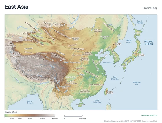
Physical
Shaded relief with mountains, deserts, rivers and peaks named.
downloadPhysical PDF
Physical, blank
The same terrain with no names, for labeling practice.
downloadBlank physical PDFThe geography of East Asia
East Asia rises from crowded coastal plains to the highest plateau in the world. Western China is the Tibetan Plateau, the dry Tarim Basin and the Gobi Desert, which reaches into Mongolia. Eastern China is lower and wetter, with the plains of the Yellow and Yangtze rivers. The Korean Peninsula is mostly mountains, and Japan is a chain of mountainous, volcanic islands off the coast.
Countries on this map
- China
- Japan
- Mongolia
- North Korea
- South Korea
- Taiwan
Major rivers
- Yangtze
- Yellow (Huang He)
- Amur
- Pearl (Xi)
- Yalu
Find it on the map
- The Tibetan Plateau in the southwest
- The Korean Peninsula between China and Japan
- Japan’s curved chain of islands
Built from real data, not stock images.
Country borders, coastlines, rivers and feature names come from Natural Earth. The terrain on the physical maps is drawn from a global elevation model built from NASA SRTM and other public surveys.
Read full methodology arrow_forward