Middle East Map
Free printable maps of the Middle East: a labeled map of its 17 countries, a blank outline map, and a physical map in labeled and blank versions.
There is no single official list of Middle Eastern countries. This map uses a common one: the countries of southwest Asia from Turkey to Iran and Yemen, plus Egypt and Cyprus.

Choose your version
Four maps of the Middle East.
All free PDFs sized for US Letter paper.

Labeled
Every country named. Small countries are numbered with a key.
downloadLabeled PDF
Blank
Country outlines only, with a name line, for quizzes and coloring.
downloadBlank PDF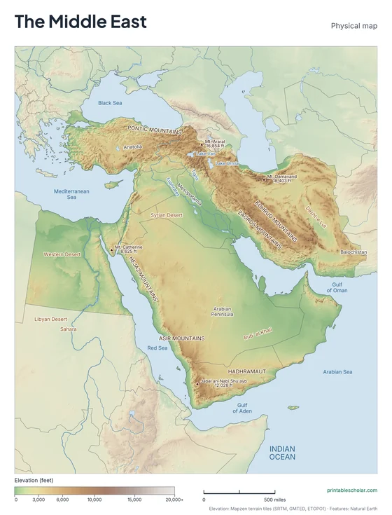
Physical
Shaded relief with mountains, deserts, rivers and peaks named.
downloadPhysical PDF
Physical, blank
The same terrain with no names, for labeling practice.
downloadBlank physical PDFThe geography of the Middle East
Much of the Middle East is desert and dry plateau. The Arabian Peninsula, the largest peninsula in the world, is mostly desert, including the Rub’ al Khali, or Empty Quarter. To the north, the Tigris and Euphrates rivers flow through Mesopotamia to the Persian Gulf. Turkey and Iran are high plateaus ringed by mountains: the Taurus and Pontic ranges in Turkey and the Zagros and Elburz in Iran. In Egypt, nearly everyone lives along the Nile. The Dead Sea, on the border of Israel and Jordan, has the lowest shore on Earth.
Countries on this map
- Bahrain
- Cyprus
- Egypt
- Iran
- Iraq
- Israel
- Jordan
- Kuwait
- Lebanon
- Oman
- Palestine
- Qatar
- Saudi Arabia
- Syria
- Turkey
- United Arab Emirates
- Yemen
Major rivers
- Nile
- Tigris
- Euphrates
- Jordan
- Karun
Find it on the map
- The Arabian Peninsula between the Red Sea and the Persian Gulf
- The Tigris and Euphrates flowing side by side
- The Nile running north through Egypt
Built from real data, not stock images.
Country borders, coastlines, rivers and feature names come from Natural Earth. The terrain on the physical maps is drawn from a global elevation model built from NASA SRTM and other public surveys.
Read full methodology arrow_forward