Oregon Landmarks Map
A free printable illustrated map of Oregon for kids. It shows 7 landmarks and natural places and 4 industries where they really are, along with the state symbols, 6 cities and a box of key facts. It comes in color and in ink-saving black and white, sized for US Letter paper.
downloadColor PDF downloadBlack and white PDF
Choose your version
Color or black and white.
Both are free, sized for US Letter paper, and come as a PDF to print or a PNG image for slides.
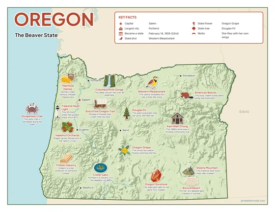
Color
The full-color map, for a wall display or a color printer.

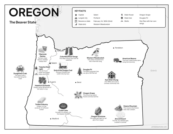
Black and white
The same map with no color or shading. Prints cleanly on a classroom printer and saves ink.

What is on the Oregon map
Every picture sits at its real location in Oregon, with a one-line fact beside it. Salem, the capital, is marked with a star.
Landmarks and natural places
- Crater Lake: Formed in a volcano, it is the deepest US lake.
- Columbia River Gorge: This deep canyon has over 90 waterfalls.
- Steens Mountain: This massive fault-block rises near a desert.
- Alvord Desert: This flat, dry lakebed gets cracked in summer.
- End of the Oregon Trail: Pioneers finished their 2,000-mile trip here.
- Kam Wah Chung: This 1880s store was a Chinese community hub.
- Yaquina Head Light: This 93-foot tower has guided ships since 1873.
What Oregon makes and grows
- Dungeness Crab: This tasty crab is harvested along the coast.
- Tillamook Dairies: Farmers make famous cheddar cheese here.
- Timber Industry: Oregon is a top producer of softwood lumber.
- Hazelnut Orchards: Oregon grows 99 percent of the nation’s crop.
State symbols
- Western Meadowlark: This yellow-breasted bird has a flute-like song.
- Oregon Grape: This shrub has yellow flowers and blue berries.
- Douglas Fir: This giant evergreen tree can grow 300 feet tall.
- American Beaver: This busy rodent builds dams using tree branches.
- Oregon Sunstone: This state gem gets its red glow from copper.
Oregon key facts
From the box on the map
- Nickname
- The Beaver State
- Capital
- Salem
- Largest city
- Portland
- Became a state
- February 14, 1859 (33rd)
- State bird
- Western Meadowlark
- State flower
- Oregon Grape
- State tree
- Douglas Fir
- Motto
- She flies with her own wings
Cities shown
- Salem (capital)
- Portland
- Eugene
- Bend
- Medford
- Pendleton
The outline, rivers and cities are drawn from map data. Pictures of crops and industries are placed in a part of the state where each is typical.