Printable Scholar
Antarctica Map
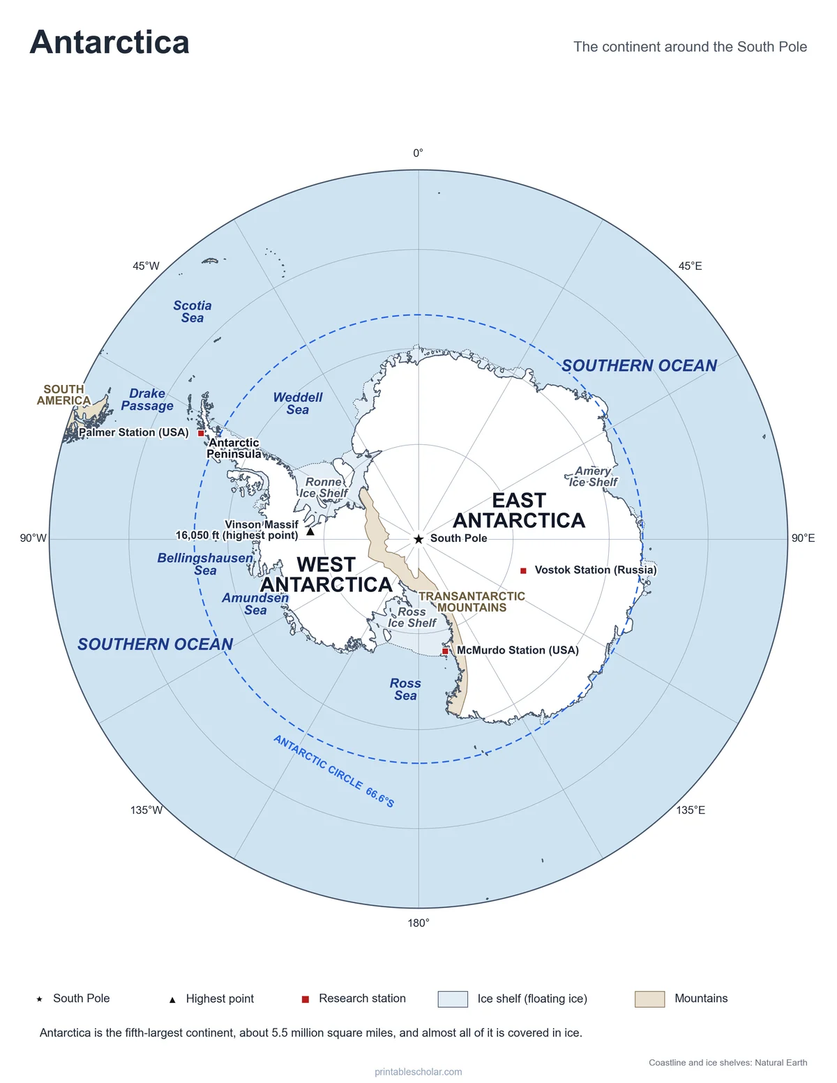
A free printable map of Antarctica, the icy continent around the South Pole. It shows East and West Antarctica, the Antarctic Peninsula, the Transantarctic Mountains, the big ice shelves, the seas of the Southern Ocean, the highest point and the main research stations. It comes in black and white or color, and as a blank map with numbered places and a word bank.
Choose your version
Black and white, color or blank.
All three are free PDFs sized for US Letter paper.
Black and white
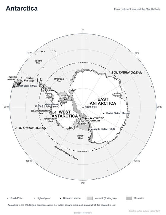
Seas, ice shelves, mountains, the South Pole, the highest point and research stations named. No color ink needed.
downloadBlack and white PDF
Color
The same map with blue oceans, white ice and shaded ice shelves and mountains.
downloadColor PDF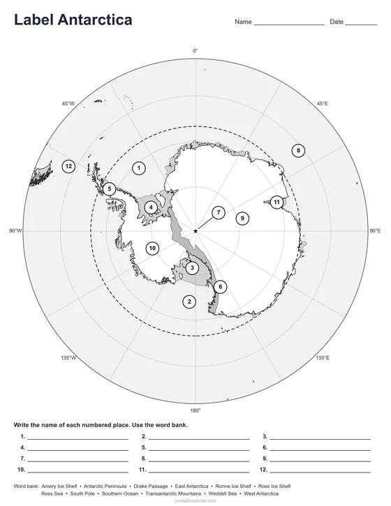
Blank
12 numbered places and a word bank. Black and white.
downloadBlank PDFThe frozen continent
Antarctica is the fifth-largest continent, about 5.5 million square miles, bigger than the United States and Mexico together. Almost all of it is buried under a sheet of ice that is about a mile thick on average. That ice holds about 60 percent of all the fresh water on Earth. Antarctica is also the coldest, windiest and driest continent: the coldest temperature ever measured on Earth, minus 128.6 degrees Fahrenheit, was recorded at Russia’s Vostok Station in 1983.
The Transantarctic Mountains cross the continent and split it in two. East Antarctica, the larger part, is a high, flat plateau of ice. West Antarctica is lower, with the Antarctic Peninsula reaching north toward South America and the Ellsworth Mountains, where Vinson Massif rises to 16,050 feet, the highest point on the continent.
Around the coast, glaciers flow into the sea and spread out as ice shelves, great sheets of floating ice. The Ross Ice Shelf, the largest, is about the size of France. The Southern Ocean surrounds the whole continent, with the Weddell Sea and the Ross Sea cutting deep into it, and the stormy Drake Passage separating the Antarctic Peninsula from the tip of South America.
No one lives in Antarctica for good. A few thousand scientists and support staff work at research stations in summer, and about a thousand stay through the dark winter. Under the Antarctic Treaty of 1959, now joined by more than 50 countries, the continent is set aside for peace and science. Roald Amundsen of Norway led the first team to reach the South Pole, on December 14, 1911.
Antarctica facts
- Area: about 5.5 million square miles
- Highest point: Vinson Massif, 16,050 feet
- Covered in ice: about 98 percent
- Coldest temperature: -128.6°F, Vostok Station
- South Pole first reached: December 14, 1911
Find it on the map
- The South Pole, in the middle of the map, where every line of longitude meets
- The Antarctic Peninsula reaching toward South America
- The Ross Ice Shelf, the biggest floating ice shelf
Coastline, ice shelves and mountain areas: Natural Earth. Antarctic Polar Stereographic projection.
Frequently asked questions
Why is the South Pole in the middle of the map?
This map looks down on Antarctica from above the South Pole, so the pole is in the center and the lines of longitude spread out from it like spokes. It is the best way to show the whole continent in its true shape. On a flat world map, Antarctica gets stretched along the bottom edge.
How big is Antarctica?
About 5.5 million square miles, making it the fifth-largest continent. It is bigger than Europe and almost twice the size of Australia.
What is an ice shelf?
A thick sheet of floating ice where a glacier flows off the land and out over the sea. The Ross and Ronne Ice Shelves are the two largest. On the map, ice shelves are shaded so you can tell them apart from the land.
Does anyone live in Antarctica?
Not permanently. Scientists and support staff from many countries live at research stations, such as McMurdo and Palmer (United States) and Vostok (Russia), for a season or a year at a time.
What is the difference between East and West Antarctica?
The Transantarctic Mountains divide them. East Antarctica is larger and sits on a high plateau of thick ice. West Antarctica is smaller and lower, and includes the Antarctic Peninsula.
How do students use the blank map?
The blank map shows the same continent with 12 numbered places and a word bank. Students write the name of each place: seas, ice shelves, the peninsula, the mountains, East and West Antarctica, the South Pole and the Drake Passage. The labeled map is the answer key.