Utah Landmarks Map
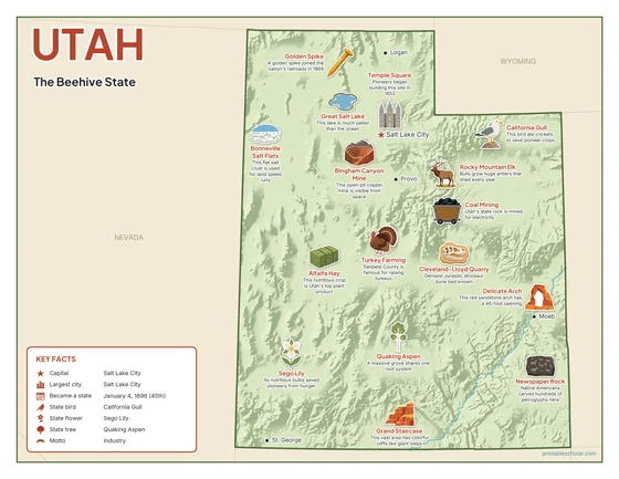
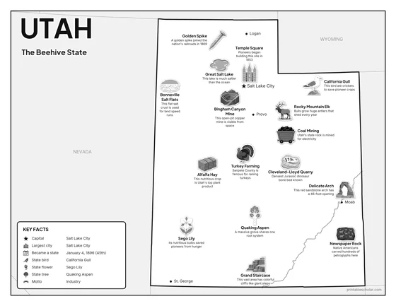
A free printable illustrated map of Utah for kids. It shows 8 landmarks and natural places and 4 industries where they really are, along with the state symbols, 5 cities and a box of key facts. It comes in color and in ink-saving black and white, sized for US Letter paper.
downloadColor PDF downloadBlack and white PDF
Choose your version
Color or black and white.
Both are free, sized for US Letter paper, and come as a PDF to print or a PNG image for slides.
Color
The full-color map, for a wall display or a color printer.

Black and white
The same map with no color or shading. Prints cleanly on a classroom printer and saves ink.

What is on the Utah map
Every picture sits at its real location in Utah, with a one-line fact beside it. Salt Lake City, the capital, is marked with a star.
Landmarks and natural places
- Great Salt Lake: This lake is much saltier than the ocean.
- Bonneville Salt Flats: This flat salt crust is used for land speed runs.
- Delicate Arch: This red sandstone arch has a 46-foot opening.
- Grand Staircase: This vast area has colorful cliffs like giant steps.
- Golden Spike: A golden spike joined the nation’s railroads in 1869.
- Temple Square: Pioneers began building this site in 1853.
- Cleveland-Lloyd Quarry: Densest Jurassic dinosaur bone bed known.
- Newspaper Rock: Native Americans carved hundreds of petroglyphs here.
What Utah makes and grows
- Bingham Canyon Mine: This open-pit copper mine is visible from space.
- Alfalfa Hay: This nutritious crop is Utah’s top plant product.
- Coal Mining: Utah’s state rock is mined for electricity.
- Turkey Farming: Sanpete County is famous for raising turkeys.
State symbols
- California Gull: This bird ate crickets to save pioneer crops.
- Sego Lily: Its nutritious bulbs saved pioneers from hunger.
- Quaking Aspen: A massive grove shares one root system.
- Rocky Mountain Elk: Bulls grow huge antlers that shed every year.
Utah key facts
From the box on the map
- Nickname
- The Beehive State
- Capital
- Salt Lake City
- Largest city
- Salt Lake City
- Became a state
- January 4, 1896 (45th)
- State bird
- California Gull
- State flower
- Sego Lily
- State tree
- Quaking Aspen
- Motto
- Industry
Cities shown
- Salt Lake City (capital)
- Provo
- St. George
- Logan
- Moab
The outline, rivers and cities are drawn from map data. Pictures of crops and industries are placed in a part of the state where each is typical.