Pennsylvania Landmarks Map
A free printable illustrated map of Pennsylvania for kids. It shows 8 landmarks and natural places and 3 industries where they really are, along with the state symbols, 6 cities and a box of key facts. It comes in color and in ink-saving black and white, sized for US Letter paper.
downloadColor PDF downloadBlack and white PDF
Choose your version
Color or black and white.
Both are free, sized for US Letter paper, and come as a PDF to print or a PNG image for slides.
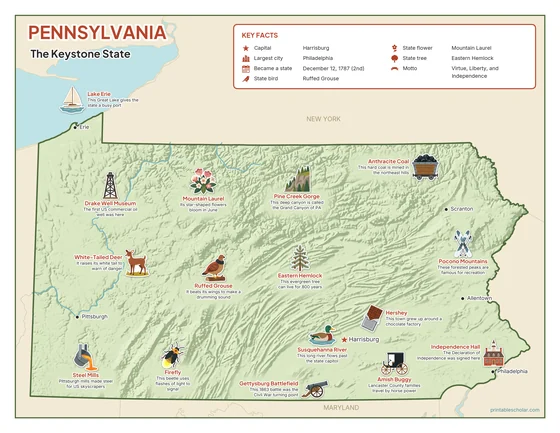
Color
The full-color map, for a wall display or a color printer.

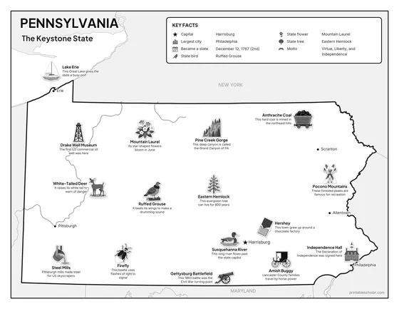
Black and white
The same map with no color or shading. Prints cleanly on a classroom printer and saves ink.

What is on the Pennsylvania map
Every picture sits at its real location in Pennsylvania, with a one-line fact beside it. Harrisburg, the capital, is marked with a star.
Landmarks and natural places
- Lake Erie: This Great Lake gives the state a busy port.
- Pine Creek Gorge: This deep canyon is called the Grand Canyon of PA.
- Pocono Mountains: These forested peaks are famous for recreation.
- Susquehanna River: This long river flows past the state capitol.
- Independence Hall: The Declaration of Independence was signed here.
- Gettysburg Battlefield: This 1863 battle was the Civil War turning point.
- Drake Well Museum: The first US commercial oil well was here.
- Amish Buggy: Lancaster County families travel by horse power.
What Pennsylvania makes and grows
- Steel Mills: Pittsburgh mills made steel for US skyscrapers.
- Hershey: This town grew up around a chocolate factory.
- Anthracite Coal: This hard coal is mined in the northeast hills.
State symbols
- Ruffed Grouse: It beats its wings to make a drumming sound.
- Mountain Laurel: Its star-shaped flowers bloom in June.
- Eastern Hemlock: This evergreen tree can live for 800 years.
- White-Tailed Deer: It raises its white tail to warn of danger.
- Firefly: This beetle uses flashes of light to signal.
Pennsylvania key facts
From the box on the map
- Nickname
- The Keystone State
- Capital
- Harrisburg
- Largest city
- Philadelphia
- Became a state
- December 12, 1787 (2nd)
- State bird
- Ruffed Grouse
- State flower
- Mountain Laurel
- State tree
- Eastern Hemlock
- Motto
- Virtue, Liberty, and Independence
Cities shown
- Harrisburg (capital)
- Philadelphia
- Pittsburgh
- Allentown
- Erie
- Scranton
The outline, rivers and cities are drawn from map data. Pictures of crops and industries are placed in a part of the state where each is typical.