
Pennsylvania State Report Kit
Everything a student needs to research and write a report on Pennsylvania: the reading, the maps and the pages to fill in. Nothing else to look up.
- 3 reading pages: Pennsylvania fun facts, History, and Land and Work
- 5 maps: landmarks, cities, county, outline, and rivers and lakes
- An 8-page My State Report booklet, from fast facts to a trip plan and a license plate to design
- A pennant to cut out and hang, two map skills sheets and a 10-question reading quiz
- Answer keys for the quiz, the fast facts and the map sheets
- One print-ready PDF, 23 pages, black and white, US Letter
Teaching all 50 states? Get every kit for $39.
Look inside
Read it, map it, write it.
The reading pages and maps hold every answer the booklet asks for. About one third of the booklet is looking things up. The rest asks students to choose, plan and explain.

What is in the Pennsylvania kit
To read and study
- Pennsylvania fun facts: six short true stories, By the Numbers and Did You Know
- History: the state’s story in order, with a timeline, people to know and words to know
- Land and Work: the land and climate, what the state grows, makes and mines, and how one leads to the other
- Five maps, including a rivers, lakes and neighbors map with a letter key
To fill in and make
- My State Report booklet: cover, Fast Facts, My Map, State Symbols, My Trip, Think Like a Geographer, Design a License Plate and Dig Deeper
- A pennant with the state’s name and outline, to color, cut out and hang
- Name the Cities and Name the Rivers and Lakes sheets, each with a word bank
- A 10-question reading quiz, with answer keys for everything that has one right answer
Free: the Pennsylvania History reading page
One page on the history of Pennsylvania for grades 3 to 5, free to print in color or black and white. It is the second reading page in the kit.
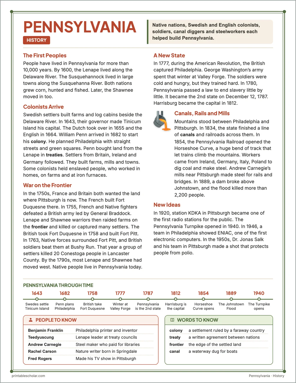
The First Peoples
People have lived in Pennsylvania for more than 10,000 years. By 1600, the Lenape lived along the Delaware River. The Susquehannock lived in large towns along the Susquehanna River. Both nations grew corn, hunted and fished. Later, the Shawnee moved in too.
Colonists Arrive
Swedish settlers built farms and log cabins beside the Delaware River. In 1643, their governor made Tinicum Island his capital. The Dutch took over in 1655 and the English in 1664. William Penn arrived in 1682 to start his colony. He planned Philadelphia with straight streets and green squares. Penn bought land from the Lenape in treaties. Settlers from Britain, Ireland and Germany followed. They built farms, mills and towns. Some colonists held enslaved people, who worked in homes, on farms and at iron furnaces.
War on the Frontier
In the 1750s, France and Britain both wanted the land where Pittsburgh is now. The French built Fort Duquesne there. In 1755, French and Native fighters defeated a British army led by General Braddock. Lenape and Shawnee warriors then raided farms on the frontier and killed or captured many settlers. The British took Fort Duquesne in 1758 and built Fort Pitt. In 1763, Native forces surrounded Fort Pitt, and British soldiers beat them at Bushy Run. That year a group of settlers killed 20 Conestoga people in Lancaster County. By the 1790s, most Lenape and Shawnee had moved west. Native people live in Pennsylvania today.
A New State
In 1777, during the American Revolution, the British captured Philadelphia. George Washington’s army spent that winter at Valley Forge. The soldiers were cold and hungry, but they trained hard. In 1780, Pennsylvania passed a law to end slavery little by little. It became the 2nd state on December 12, 1787. Harrisburg became the capital in 1812.
Canals, Rails and Mills
Mountains stood between Philadelphia and Pittsburgh. In 1834, the state finished a line of canals and railroads across them. In 1854, the Pennsylvania Railroad opened the Horseshoe Curve, a huge bend of track that let trains climb the mountains. Workers came from Ireland, Germany, Italy, Poland to dig coal and make steel. Andrew Carnegie’s mills near Pittsburgh made steel for rails and bridges. In 1889, a dam broke above Johnstown, and the flood killed more than 2,200 people.
New Ideas
In 1920, station KDKA in Pittsburgh became one of the first radio stations for the public. The Pennsylvania Turnpike opened in 1940. In 1946, a team in Philadelphia showed ENIAC, one of the first electronic computers. In the 1950s, Dr. Jonas Salk and his team in Pittsburgh made a shot that protects people from polio.
Pennsylvania through time
- 1643 Swedes settle Tinicum Island
- 1682 Penn plans Philadelphia
- 1758 British take Fort Duquesne
- 1777 Winter at Valley Forge
- 1787 Pennsylvania is the 2nd state
- 1812 Harrisburg is the capital
- 1854 Horseshoe Curve opens
- 1889 The Johnstown Flood
- 1940 The Turnpike opens
People to know
- Benjamin Franklin: Philadelphia printer and inventor
- Teedyuscung: Lenape leader at treaty councils
- Andrew Carnegie: Steel maker who paid for libraries
- Rachel Carson: Nature writer born in Springdale
- Fred Rogers: Made his TV show in Pittsburgh
Free Pennsylvania maps
Each of these maps is free to print on its own page. The kit puts them in one file with the reading pages and the booklet.