Nebraska Landmarks Map
A free printable illustrated map of Nebraska for kids. It shows 8 landmarks and natural places and 3 industries where they really are, along with the state symbols, 6 cities and a box of key facts. It comes in color and in ink-saving black and white, sized for US Letter paper.
downloadColor PDF downloadBlack and white PDF
Choose your version
Color or black and white.
Both are free, sized for US Letter paper, and come as a PDF to print or a PNG image for slides.
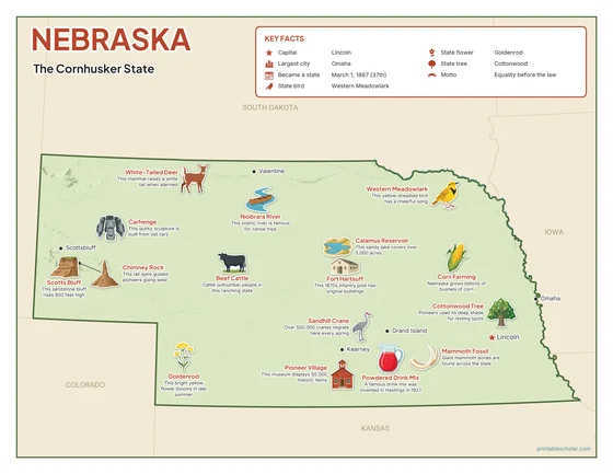
Color
The full-color map, for a wall display or a color printer.

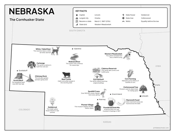
Black and white
The same map with no color or shading. Prints cleanly on a classroom printer and saves ink.

What is on the Nebraska map
Every picture sits at its real location in Nebraska, with a one-line fact beside it. Lincoln, the capital, is marked with a star.
Landmarks and natural places
- Sandhill Crane: Over 500,000 cranes migrate here every spring.
- Calamus Reservoir: This sandy lake covers over 5,000 acres.
- Scotts Bluff: This sandstone bluff rises 800 feet high.
- Niobrara River: This scenic river is famous for canoe trips.
- Chimney Rock: This tall spire guided pioneers going west.
- Carhenge: This quirky sculpture is built from old cars.
- Fort Hartsuff: This 1870s infantry post has original buildings.
- Pioneer Village: This museum displays 50,000 historic items.
What Nebraska makes and grows
- Corn Farming: Nebraska grows billions of bushels of corn.
- Beef Cattle: Cattle outnumber people in this ranching state.
- Powdered Drink Mix: A famous drink mix was invented in Hastings in 1927.
State symbols
- Western Meadowlark: This yellow-breasted bird has a cheerful song.
- Goldenrod: This bright yellow flower blooms in late summer.
- Cottonwood Tree: Pioneers used its deep shade for resting spots.
- White-Tailed Deer: This mammal raises a white tail when alarmed.
- Mammoth Fossil: Giant mammoth bones are found across the state.
Nebraska key facts
From the box on the map
- Nickname
- The Cornhusker State
- Capital
- Lincoln
- Largest city
- Omaha
- Became a state
- March 1, 1867 (37th)
- State bird
- Western Meadowlark
- State flower
- Goldenrod
- State tree
- Cottonwood
- Motto
- Equality before the law
Cities shown
- Lincoln (capital)
- Omaha
- Grand Island
- Kearney
- Scottsbluff
- Valentine
The outline, rivers and cities are drawn from map data. Pictures of crops and industries are placed in a part of the state where each is typical.