Montana Landmarks Map
A free printable illustrated map of Montana for kids. It shows 7 landmarks and natural places and 4 industries where they really are, along with the state symbols, 5 cities and a box of key facts. It comes in color and in ink-saving black and white, sized for US Letter paper.
downloadColor PDF downloadBlack and white PDF
Choose your version
Color or black and white.
Both are free, sized for US Letter paper, and come as a PDF to print or a PNG image for slides.
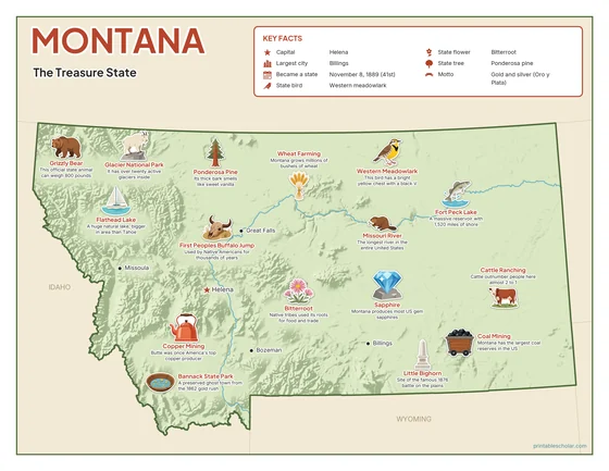
Color
The full-color map, for a wall display or a color printer.

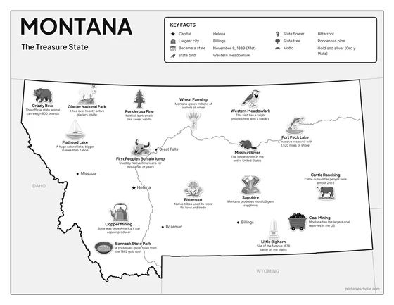
Black and white
The same map with no color or shading. Prints cleanly on a classroom printer and saves ink.

What is on the Montana map
Every picture sits at its real location in Montana, with a one-line fact beside it. Helena, the capital, is marked with a star.
Landmarks and natural places
- Glacier National Park: It has over twenty active glaciers inside.
- Flathead Lake: A huge natural lake, bigger in area than Tahoe.
- Missouri River: The longest river in the entire United States.
- Fort Peck Lake: A massive reservoir with 1,520 miles of shore.
- Little Bighorn: Site of the famous 1876 battle on the plains.
- Bannack State Park: A preserved ghost town from the 1862 gold rush.
- First Peoples Buffalo Jump: Used by Native Americans for thousands of years.
What Montana makes and grows
- Wheat Farming: Montana grows millions of bushels of wheat.
- Copper Mining: Butte was once America’s top copper producer.
- Cattle Ranching: Cattle outnumber people here almost 2 to 1.
- Coal Mining: Montana has the largest coal reserves in the US.
State symbols
- Western Meadowlark: This bird has a bright yellow chest with a black V.
- Bitterroot: Native tribes used its roots for food and trade.
- Ponderosa Pine: Its thick bark smells like sweet vanilla.
- Grizzly Bear: This official state animal can weigh 800 pounds.
- Sapphire: Montana produces most US gem sapphires.
Montana key facts
From the box on the map
- Nickname
- The Treasure State
- Capital
- Helena
- Largest city
- Billings
- Became a state
- November 8, 1889 (41st)
- State bird
- Western meadowlark
- State flower
- Bitterroot
- State tree
- Ponderosa pine
- Motto
- Gold and silver (Oro y Plata)
Cities shown
- Helena (capital)
- Billings
- Missoula
- Great Falls
- Bozeman
The outline, rivers and cities are drawn from map data. Pictures of crops and industries are placed in a part of the state where each is typical.