Kansas Landmarks Map
A free printable illustrated map of Kansas for kids. It shows 8 landmarks and natural places and 3 industries where they really are, along with the state symbols, 6 cities and a box of key facts. It comes in color and in ink-saving black and white, sized for US Letter paper.
downloadColor PDF downloadBlack and white PDF
Choose your version
Color or black and white.
Both are free, sized for US Letter paper, and come as a PDF to print or a PNG image for slides.
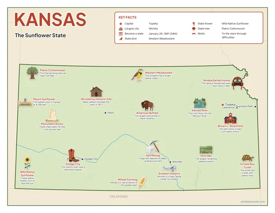
Color
The full-color map, for a wall display or a color printer.

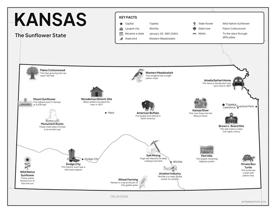
Black and white
The same map with no color or shading. Prints cleanly on a classroom printer and saves ink.

What is on the Kansas map
Every picture sits at its real location in Kansas, with a one-line fact beside it. Topeka, the capital, is marked with a star.
Landmarks and natural places
- Monument Rocks: These chalk pillars formed in an ancient sea.
- Flint Hills: The largest remaining tallgrass prairie.
- Kansas River: This river flows into the Missouri River.
- Mount Sunflower: The highest point in Kansas at 4,039 feet.
- Dodge City: This historic town was a wild west outpost.
- Amelia Earhart Home: The famous female pilot was born here in 1897.
- Brown v. Board Site: This site marks a major civil rights victory.
- Nicodemus Historic Site: Black settlers founded this town in 1877.
What Kansas makes and grows
- Wheat Farming: Kansas is a top producer of this golden grain.
- Aviation Industry: Wichita is a major global center for aviation.
- Salt Mining: Huge salt deposits lie deep underground here.
State symbols
- Western Meadowlark: This songbird has a bright yellow chest.
- Wild Native Sunflower: These yellow flowers turn to face the sun.
- Plains Cottonwood: This fast-growing tree can reach 100 feet.
- American Buffalo: The largest land animal in North America.
- Ornate Box Turtle: This turtle has a shell with yellow lines.
Kansas key facts
From the box on the map
- Nickname
- The Sunflower State
- Capital
- Topeka
- Largest city
- Wichita
- Became a state
- January 29, 1861 (34th)
- State bird
- Western Meadowlark
- State flower
- Wild Native Sunflower
- State tree
- Plains Cottonwood
- Motto
- To the stars through difficulties
Cities shown
- Topeka (capital)
- Wichita
- Overland Park
- Dodge City
- Lawrence
- Hays
The outline, rivers and cities are drawn from map data. Pictures of crops and industries are placed in a part of the state where each is typical.