Iowa Landmarks Map
A free printable illustrated map of Iowa for kids. It shows 8 landmarks and natural places and 4 industries where they really are, along with the state symbols, 6 cities and a box of key facts. It comes in color and in ink-saving black and white, sized for US Letter paper.
downloadColor PDF downloadBlack and white PDF
Choose your version
Color or black and white.
Both are free, sized for US Letter paper, and come as a PDF to print or a PNG image for slides.
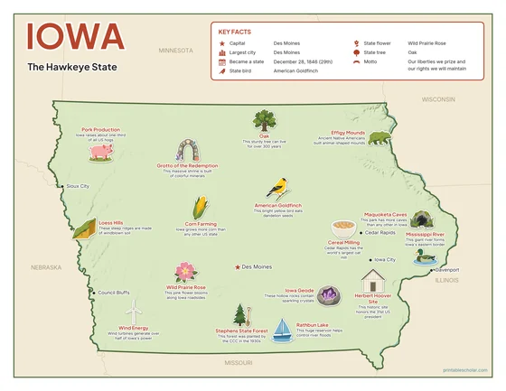
Color
The full-color map, for a wall display or a color printer.

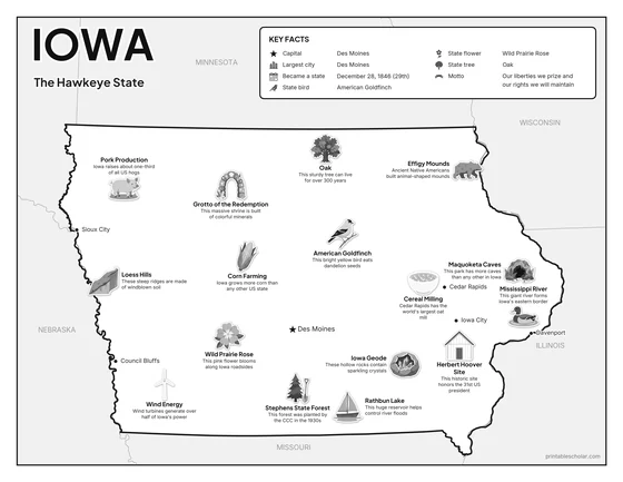
Black and white
The same map with no color or shading. Prints cleanly on a classroom printer and saves ink.

What is on the Iowa map
Every picture sits at its real location in Iowa, with a one-line fact beside it. Des Moines, the capital, is marked with a star.
Landmarks and natural places
- Loess Hills: These steep ridges are made of windblown soil.
- Maquoketa Caves: This park has more caves than any other in Iowa.
- Rathbun Lake: This huge reservoir helps control river floods.
- Mississippi River: This giant river forms Iowa’s eastern border.
- Effigy Mounds: Ancient Native Americans built animal-shaped mounds.
- Herbert Hoover Site: This historic site honors the 31st US president.
- Grotto of the Redemption: This massive shrine is built of colorful minerals.
- Stephens State Forest: This forest was planted by the CCC in the 1930s.
What Iowa makes and grows
- Corn Farming: Iowa grows more corn than any other US state.
- Pork Production: Iowa raises about one-third of all US hogs.
- Wind Energy: Wind turbines generate over half of Iowa’s power.
- Cereal Milling: Cedar Rapids has the world’s largest oat mill.
State symbols
- American Goldfinch: This bright yellow bird eats dandelion seeds.
- Wild Prairie Rose: This pink flower blooms along Iowa roadsides.
- Oak: This sturdy tree can live for over 300 years.
- Iowa Geode: These hollow rocks contain sparkling crystals.
Iowa key facts
From the box on the map
- Nickname
- The Hawkeye State
- Capital
- Des Moines
- Largest city
- Des Moines
- Became a state
- December 28, 1846 (29th)
- State bird
- American Goldfinch
- State flower
- Wild Prairie Rose
- State tree
- Oak
- Motto
- Our liberties we prize and our rights we will maintain
Cities shown
- Des Moines (capital)
- Cedar Rapids
- Davenport
- Sioux City
- Iowa City
- Council Bluffs
The outline, rivers and cities are drawn from map data. Pictures of crops and industries are placed in a part of the state where each is typical.