Wyoming Landmarks Map
A free printable illustrated map of Wyoming for kids. It shows 9 landmarks and natural places and 3 industries where they really are, along with the state symbols, 6 cities and a box of key facts. It comes in color and in ink-saving black and white, sized for US Letter paper.
downloadColor PDF downloadBlack and white PDF
Choose your version
Color or black and white.
Both are free, sized for US Letter paper, and come as a PDF to print or a PNG image for slides.
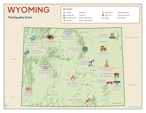
Color
The full-color map, for a wall display or a color printer.

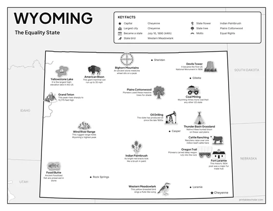
Black and white
The same map with no color or shading. Prints cleanly on a classroom printer and saves ink.

What is on the Wyoming map
Every picture sits at its real location in Wyoming, with a one-line fact beside it. Cheyenne, the capital, is marked with a star.
Landmarks and natural places
- Yellowstone Lake: It is the largest high-elevation lake in the US.
- Grand Teton: This peak rises sharply to 13,775 feet high.
- Devils Tower: It became the first US National Monument in 1906.
- Wind River Range: This rugged range holds Wyoming’s highest peak.
- Fossil Butte: Ancient fossilized fish are preserved in stone.
- Oregon Trail: Pioneers carved deep wagon ruts into the rock.
- Fort Laramie: This historic 1834 post was a major fur trade hub.
- Bighorn Mountains: An ancient stone medicine wheel sits on a peak.
- Thunder Basin Grassland: Native tribes hunted bison on these vast plains.
What Wyoming makes and grows
- Coal Mining: Wyoming mines more coal than any other US state.
- Oil Drilling: The state has produced oil since the late 1800s.
- Cattle Ranching: Ranchers raise over one million beef cattle here.
State symbols
- Western Meadowlark: This yellow-breasted bird sings a flute-like song.
- Indian Paintbrush: Its bright red bracts look like a brush in paint.
- Plains Cottonwood: Pioneers used these massive trees for shade.
- American Bison: This giant mammal can run up to 35 mph.
Wyoming key facts
From the box on the map
- Nickname
- The Equality State
- Capital
- Cheyenne
- Largest city
- Cheyenne
- Became a state
- July 10, 1890 (44th)
- State bird
- Western Meadowlark
- State flower
- Indian Paintbrush
- State tree
- Plains Cottonwood
- Motto
- Equal Rights
Cities shown
- Cheyenne (capital)
- Casper
- Gillette
- Laramie
- Rock Springs
- Sheridan
The outline, rivers and cities are drawn from map data. Pictures of crops and industries are placed in a part of the state where each is typical.