Wisconsin Landmarks Map
A free printable illustrated map of Wisconsin for kids. It shows 8 landmarks and natural places and 4 industries where they really are, along with the state symbols, 5 cities and a box of key facts. It comes in color and in ink-saving black and white, sized for US Letter paper.
downloadColor PDF downloadBlack and white PDF
Choose your version
Color or black and white.
Both are free, sized for US Letter paper, and come as a PDF to print or a PNG image for slides.
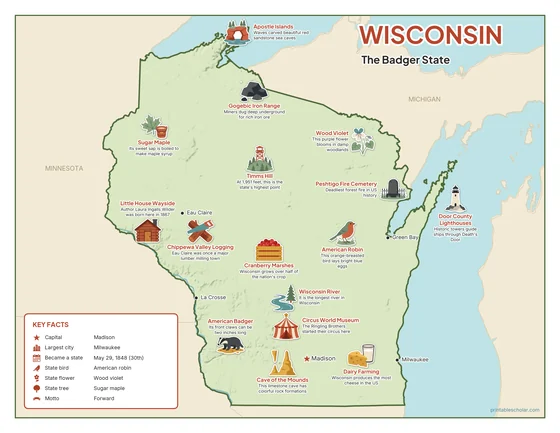
Color
The full-color map, for a wall display or a color printer.

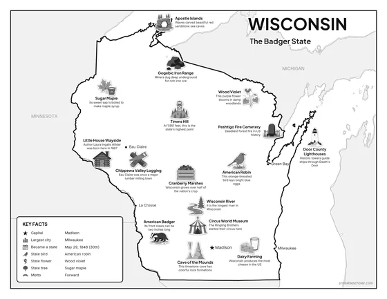
Black and white
The same map with no color or shading. Prints cleanly on a classroom printer and saves ink.

What is on the Wisconsin map
Every picture sits at its real location in Wisconsin, with a one-line fact beside it. Madison, the capital, is marked with a star.
Landmarks and natural places
- Apostle Islands: Waves carved beautiful red sandstone sea caves.
- Wisconsin River: It is the longest river in Wisconsin.
- Timms Hill: At 1,951 feet, this is the state’s highest point.
- Cave of the Mounds: This limestone cave has colorful rock formations.
- Peshtigo Fire Cemetery: Deadliest forest fire in US history.
- Little House Wayside: Author Laura Ingalls Wilder was born here in 1867.
- Circus World Museum: The Ringling Brothers started their circus here.
- Door County Lighthouses: Historic towers guide ships through Death’s Door.
What Wisconsin makes and grows
- Cranberry Marshes: Wisconsin grows over half of the nation’s crop.
- Dairy Farming: Wisconsin produces the most cheese in the US.
- Gogebic Iron Range: Miners dug deep underground for rich iron ore.
- Chippewa Valley Logging: Eau Claire was once a major lumber milling town.
State symbols
- Sugar Maple: Its sweet sap is boiled to make maple syrup.
- American Robin: This orange-breasted bird lays bright blue eggs.
- Wood Violet: This purple flower blooms in damp woodlands.
- American Badger: Its front claws can be two inches long.
Wisconsin key facts
From the box on the map
- Nickname
- The Badger State
- Capital
- Madison
- Largest city
- Milwaukee
- Became a state
- May 29, 1848 (30th)
- State bird
- American robin
- State flower
- Wood violet
- State tree
- Sugar maple
- Motto
- Forward
Cities shown
- Madison (capital)
- Milwaukee
- Green Bay
- Eau Claire
- La Crosse
The outline, rivers and cities are drawn from map data. Pictures of crops and industries are placed in a part of the state where each is typical.