Vermont Landmarks Map
A free printable illustrated map of Vermont for kids. It shows 7 landmarks and natural places and 5 industries where they really are, along with the state symbols, 6 cities and a box of key facts. It comes in color and in ink-saving black and white, sized for US Letter paper.
downloadColor PDF downloadBlack and white PDF
Choose your version
Color or black and white.
Both are free, sized for US Letter paper, and come as a PDF to print or a PNG image for slides.
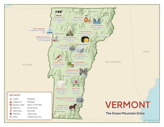
Color
The full-color map, for a wall display or a color printer.

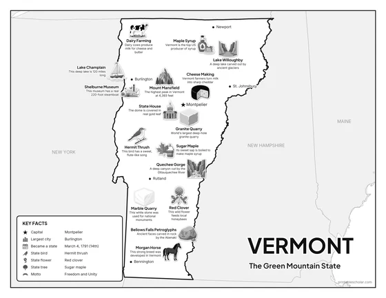
Black and white
The same map with no color or shading. Prints cleanly on a classroom printer and saves ink.

What is on the Vermont map
Every picture sits at its real location in Vermont, with a one-line fact beside it. Montpelier, the capital, is marked with a star.
Landmarks and natural places
- Lake Champlain: This deep lake is 120 miles long.
- Mount Mansfield: The highest peak in Vermont at 4,393 feet.
- Lake Willoughby: A deep lake carved out by ancient glaciers.
- Quechee Gorge: A deep canyon cut by the Ottauquechee River.
- State House: The dome is covered in real gold leaf.
- Shelburne Museum: This museum has a real 220-foot steamboat.
- Bellows Falls Petroglyphs: Ancient faces carved in rock by the Abenaki.
What Vermont makes and grows
- Maple Syrup: Vermont is the top US producer of syrup.
- Dairy Farming: Dairy cows produce milk for cheese and butter.
- Granite Quarry: World’s largest deep-hole granite quarry.
- Marble Quarry: This white stone was used for national monuments.
- Cheese Making: Vermont farmers turn milk into sharp cheddar.
State symbols
- Hermit Thrush: This bird has a sweet, flute-like song.
- Red Clover: This wild flower feeds local honeybees.
- Sugar Maple: Its sweet sap is boiled to make maple syrup.
- Morgan Horse: This strong breed was developed in Vermont.
Vermont key facts
From the box on the map
- Nickname
- The Green Mountain State
- Capital
- Montpelier
- Largest city
- Burlington
- Became a state
- March 4, 1791 (14th)
- State bird
- Hermit thrush
- State flower
- Red clover
- State tree
- Sugar maple
- Motto
- Freedom and Unity
Cities shown
- Montpelier (capital)
- Burlington
- Rutland
- Bennington
- St. Johnsbury
- Newport
The outline, rivers and cities are drawn from map data. Pictures of crops and industries are placed in a part of the state where each is typical.