Ohio Landmarks Map
A free printable illustrated map of Ohio for kids. It shows 8 landmarks and natural places and 3 industries where they really are, along with the state symbols, 6 cities and a box of key facts. It comes in color and in ink-saving black and white, sized for US Letter paper.
downloadColor PDF downloadBlack and white PDF
Choose your version
Color or black and white.
Both are free, sized for US Letter paper, and come as a PDF to print or a PNG image for slides.
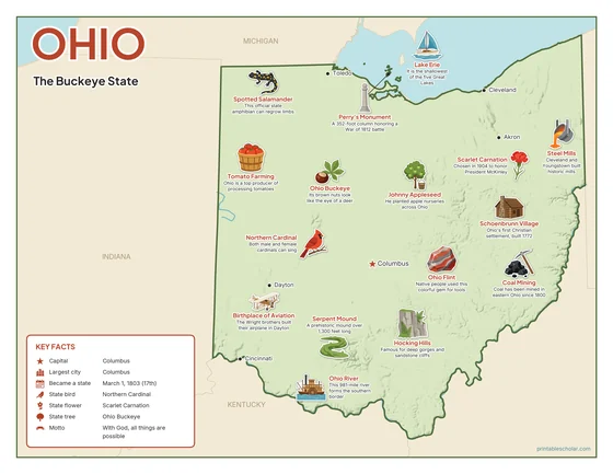
Color
The full-color map, for a wall display or a color printer.

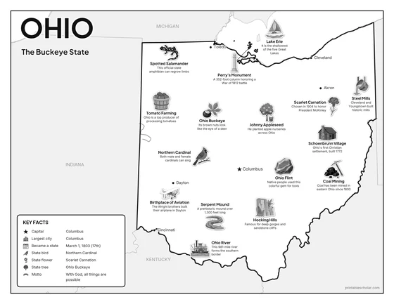
Black and white
The same map with no color or shading. Prints cleanly on a classroom printer and saves ink.

What is on the Ohio map
Every picture sits at its real location in Ohio, with a one-line fact beside it. Columbus, the capital, is marked with a star.
Landmarks and natural places
- Lake Erie: It is the shallowest of the five Great Lakes.
- Hocking Hills: Famous for deep gorges and sandstone cliffs.
- Ohio River: This 981-mile river forms the southern border.
- Serpent Mound: A prehistoric mound over 1,300 feet long.
- Birthplace of Aviation: The Wright brothers built their airplane in Dayton.
- Schoenbrunn Village: Ohio’s first Christian settlement, built 1772.
- Perry’s Monument: A 352-foot column honoring a War of 1812 battle.
- Johnny Appleseed: He planted apple nurseries across Ohio.
What Ohio makes and grows
- Tomato Farming: Ohio is a top producer of processing tomatoes.
- Coal Mining: Coal has been mined in eastern Ohio since 1800.
- Steel Mills: Cleveland and Youngstown built historic mills.
State symbols
- Northern Cardinal: Both male and female cardinals can sing.
- Scarlet Carnation: Chosen in 1904 to honor President McKinley.
- Ohio Buckeye: Its brown nuts look like the eye of a deer.
- Spotted Salamander: This official state amphibian can regrow limbs.
- Ohio Flint: Native people used this colorful gem for tools.
Ohio key facts
From the box on the map
- Nickname
- The Buckeye State
- Capital
- Columbus
- Largest city
- Columbus
- Became a state
- March 1, 1803 (17th)
- State bird
- Northern Cardinal
- State flower
- Scarlet Carnation
- State tree
- Ohio Buckeye
- Motto
- With God, all things are possible
Cities shown
- Columbus (capital)
- Cleveland
- Cincinnati
- Toledo
- Akron
- Dayton
The outline, rivers and cities are drawn from map data. Pictures of crops and industries are placed in a part of the state where each is typical.