North Carolina Landmarks Map
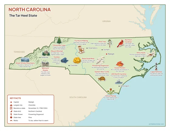
A free printable illustrated map of North Carolina for kids. It shows 8 landmarks and natural places and 4 industries where they really are, along with the state symbols, 6 cities and a box of key facts. It comes in color and in ink-saving black and white, sized for US Letter paper.
downloadColor PDF downloadBlack and white PDF
Choose your version
Color or black and white.
Both are free, sized for US Letter paper, and come as a PDF to print or a PNG image for slides.
Color
The full-color map, for a wall display or a color printer.

Black and white
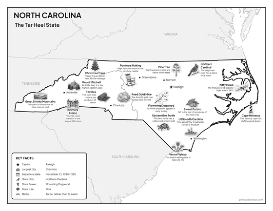
The same map with no color or shading. Prints cleanly on a classroom printer and saves ink.

What is on the North Carolina map
Every picture sits at its real location in North Carolina, with a one-line fact beside it. Raleigh, the capital, is marked with a star.
Landmarks and natural places
- Mount Mitchell: At 6,684 feet, it is the highest Eastern peak.
- Great Smoky Mountains: This park is famous for its blue-colored mist.
- Cape Hatteras: This famous cape has shifting sand dunes.
- Venus Flytrap: This insect-eating plant is native to NC.
- Kitty Hawk: The first powered airplane flight was in 1903.
- USS North Carolina: This World War II battleship is now a museum.
- Biltmore Estate: This 250-room mansion is the largest US home.
- Reed Gold Mine: The first US gold rush started here in 1799.
What North Carolina makes and grows
- Sweet Potato: NC is the top US producer of this root crop.
- Furniture Making: High Point is known as the furniture capital.
- Textiles: The state was once a top producer of denim.
- Christmas Trees: Fraser firs are grown here for the holidays.
State symbols
- Northern Cardinal: The bright red male has a black face mask.
- Flowering Dogwood: Its white blossoms appear in early spring.
- Pine Tree: Eight species of pine are native to the state.
- Eastern Box Turtle: This land turtle has a yellow and brown shell.
North Carolina key facts
From the box on the map
- Nickname
- The Tar Heel State
- Capital
- Raleigh
- Largest city
- Charlotte
- Became a state
- November 21, 1789 (12th)
- State bird
- Northern Cardinal
- State flower
- Flowering Dogwood
- State tree
- Pine
- Motto
- To be, rather than to seem
Cities shown
- Raleigh (capital)
- Charlotte
- Greensboro
- Durham
- Wilmington
- Asheville
The outline, rivers and cities are drawn from map data. Pictures of crops and industries are placed in a part of the state where each is typical.