New Jersey Landmarks Map
A free printable illustrated map of New Jersey for kids. It shows 8 landmarks and natural places and 4 industries where they really are, along with the state symbols, 5 cities and a box of key facts. It comes in color and in ink-saving black and white, sized for US Letter paper.
downloadColor PDF downloadBlack and white PDF
Choose your version
Color or black and white.
Both are free, sized for US Letter paper, and come as a PDF to print or a PNG image for slides.
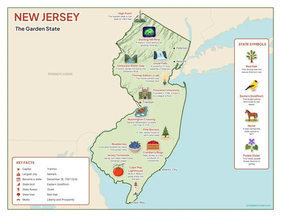
Color
The full-color map, for a wall display or a color printer.

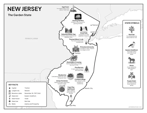
Black and white
The same map with no color or shading. Prints cleanly on a classroom printer and saves ink.

What is on the New Jersey map
Every picture sits at its real location in New Jersey, with a one-line fact beside it. Trenton, the capital, is marked with a star.
Landmarks and natural places
- High Point: The highest peak in the state at 1,803 feet.
- Delaware Water Gap: A scenic gorge carved by the Delaware River.
- Thomas Edison’s Lab: The movie camera was invented here.
- Great Falls: A powerful 77-foot waterfall in Paterson.
- Princeton University: Founded in 1746, a historic Ivy League school.
- Washington Crossing: General Washington crossed the river in 1776.
- Pine Barrens: A vast, sandy forest of pitch pine trees.
- Cape May Lighthouse: Built in 1859 to guide ships into the bay.
What New Jersey makes and grows
- Sterling Hill Mine: A historic mine famous for glowing minerals.
- Jersey Tomatoes: Sandy soil helps make these tomatoes sweet.
- Cranberry Bogs: New Jersey is a top producer of cranberries.
- Blueberries: Cultivated blueberries were first grown here.
State symbols
- Red Oak: This strong tree has leaves that turn red.
- Eastern Goldfinch: This bright yellow bird loves to eat seeds.
- Horse: It was named the state animal in 1977.
- Purple Violet: This hardy purple flower blooms in spring.
New Jersey key facts
From the box on the map
- Nickname
- The Garden State
- Capital
- Trenton
- Largest city
- Newark
- Became a state
- December 18, 1787 (3rd)
- State bird
- Eastern Goldfinch
- State flower
- Violet
- State tree
- Red Oak
- Motto
- Liberty and Prosperity
Cities shown
- Trenton (capital)
- Newark
- Paterson
- Atlantic City
- Cape May
The outline, rivers and cities are drawn from map data. Pictures of crops and industries are placed in a part of the state where each is typical.