Nevada Landmarks Map
A free printable illustrated map of Nevada for kids. It shows 8 landmarks and natural places and 3 industries where they really are, along with the state symbols, 6 cities and a box of key facts. It comes in color and in ink-saving black and white, sized for US Letter paper.
downloadColor PDF downloadBlack and white PDF
Choose your version
Color or black and white.
Both are free, sized for US Letter paper, and come as a PDF to print or a PNG image for slides.
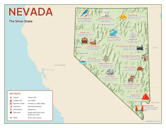
Color
The full-color map, for a wall display or a color printer.

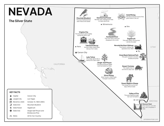
Black and white
The same map with no color or shading. Prints cleanly on a classroom printer and saves ink.

What is on the Nevada map
Every picture sits at its real location in Nevada, with a one-line fact beside it. Carson City, the capital, is marked with a star.
Landmarks and natural places
- Lake Tahoe: This deep alpine lake is famous for clear water.
- Great Basin National Park: This park is home to ancient bristlecone pines.
- Valley of Fire: This park features bright red rock formations.
- Humboldt River: This river flows west and disappears into a sink.
- Hoover Dam: This massive concrete dam was completed in 1936.
- Nevada Northern Railway: This historic railway has operated since 1905.
- Tule Duck Decoy: Ancient tribes made these decoys from reeds.
- Virginia City: This boomtown grew rapidly during the silver rush.
What Nevada makes and grows
- Gold Mining: Nevada produces most of the gold mined in the US.
- Silver Mining: Silver found in 1900 made Tonopah a boomtown.
- Geothermal Power: Nevada uses underground heat to make electricity.
State symbols
- Mountain Bluebird: This blue-feathered bird eats insects and seeds.
- Sagebrush: This gray-green shrub grows across the state.
- Single-leaf Pinyon: This pine produces edible nuts harvested by tribes.
- Desert Bighorn Sheep: This sheep can survive for days without water.
- Desert Tortoise: This reptile lives in burrows to stay cool.
Nevada key facts
From the box on the map
- Nickname
- The Silver State
- Capital
- Carson City
- Largest city
- Las Vegas
- Became a state
- October 31, 1864 (36th)
- State bird
- Mountain Bluebird
- State flower
- Sagebrush
- State tree
- Single-leaf Pinyon and Bristlecone Pine
- Motto
- All for Our Country
Cities shown
- Carson City (capital)
- Las Vegas
- Reno
- Elko
- Ely
- Winnemucca
The outline, rivers and cities are drawn from map data. Pictures of crops and industries are placed in a part of the state where each is typical.