Minnesota Landmarks Map
A free printable illustrated map of Minnesota for kids. It shows 8 landmarks and natural places and 3 industries where they really are, along with the state symbols, 6 cities and a box of key facts. It comes in color and in ink-saving black and white, sized for US Letter paper.
downloadColor PDF downloadBlack and white PDF
Choose your version
Color or black and white.
Both are free, sized for US Letter paper, and come as a PDF to print or a PNG image for slides.
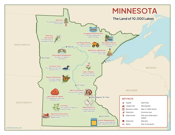
Color
The full-color map, for a wall display or a color printer.

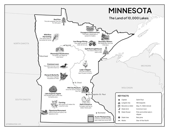
Black and white
The same map with no color or shading. Prints cleanly on a classroom printer and saves ink.

What is on the Minnesota map
Every picture sits at its real location in Minnesota, with a one-line fact beside it. Minneapolis-St. Paul, the capital, is marked with a star.
Landmarks and natural places
- Mississippi Headwaters: The great river begins at Lake Itasca.
- Boundary Waters: This wilderness has over 1,100 lakes.
- Voyageurs National Park: This water-based park is named for traders.
- Pipestone Monument: Native Americans quarry red pipestone here.
- Split Rock Lighthouse: This historic beacon was built in 1910.
- Mall of America: This giant mall has an indoor theme park.
- Mill City Museum: Once the world’s largest flour mill.
- Austin Meatpacking: A famous canned meat has been made here since 1937.
What Minnesota makes and grows
- Iron Range Mining: This region produces most US iron ore.
- Wild Rice Harvesting: This native grass is harvested by canoe.
- Farming: Rich prairie soil makes this a top farm area.
State symbols
- Common Loon: This water bird has a red eye and a loud cry.
- Lady’s Slipper: This rare orchid can take 16 years to bloom.
- Red Pine: This tall evergreen can live for 400 years.
- Lake Superior Agate: This banded quartz stone was formed by lava.
- Monarch Butterfly: This insect migrates thousands of miles.
Minnesota key facts
From the box on the map
- Nickname
- The Land of 10,000 Lakes
- Capital
- Saint Paul
- Largest city
- Minneapolis
- Became a state
- May 11, 1858 (32nd)
- State bird
- Common loon
- State flower
- Pink and white lady’s slipper
- State tree
- Red pine
- Motto
- Star of the North
Cities shown
- Minneapolis-St. Paul (capital)
- Duluth
- Rochester
- Moorhead
- Bemidji
- St. Cloud
The outline, rivers and cities are drawn from map data. Pictures of crops and industries are placed in a part of the state where each is typical.