Michigan Landmarks Map
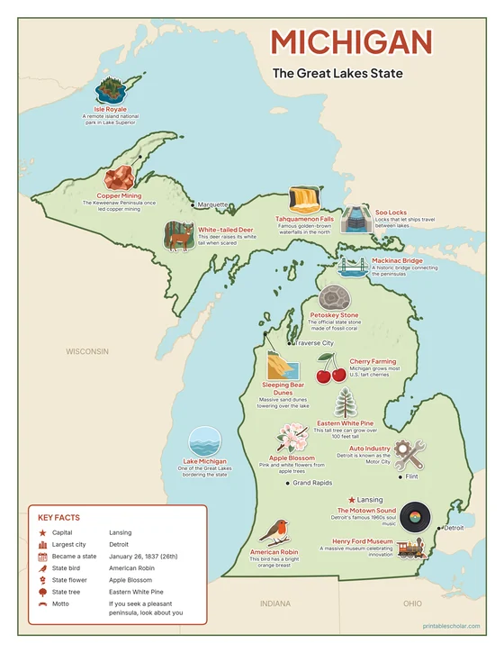
A free printable illustrated map of Michigan for kids. It shows 8 landmarks and natural places and 3 industries where they really are, along with the state symbols, 6 cities and a box of key facts. It comes in color and in ink-saving black and white, sized for US Letter paper.
downloadColor PDF downloadBlack and white PDF
Choose your version
Color or black and white.
Both are free, sized for US Letter paper, and come as a PDF to print or a PNG image for slides.
Color
The full-color map, for a wall display or a color printer.

Black and white
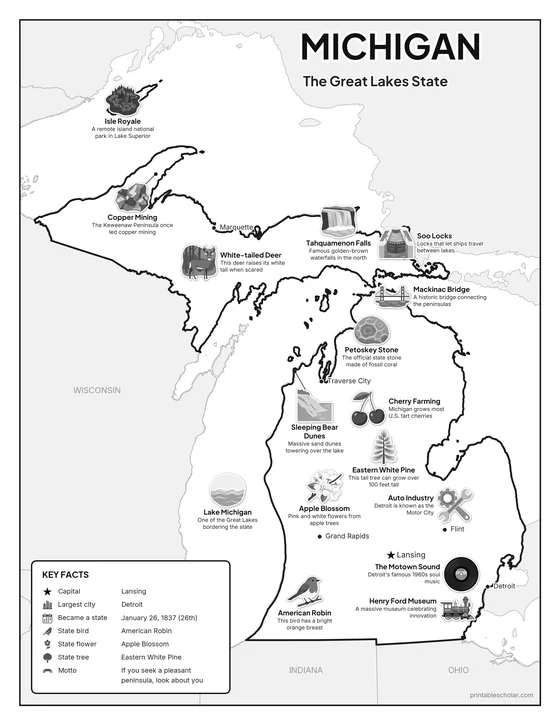
The same map with no color or shading. Prints cleanly on a classroom printer and saves ink.

What is on the Michigan map
Every picture sits at its real location in Michigan, with a one-line fact beside it. Lansing, the capital, is marked with a star.
Landmarks and natural places
- Sleeping Bear Dunes: Massive sand dunes towering over the lake.
- Tahquamenon Falls: Famous golden-brown waterfalls in the north.
- Isle Royale: A remote island national park in Lake Superior.
- Lake Michigan: One of the Great Lakes bordering the state.
- Mackinac Bridge: A historic bridge connecting the peninsulas.
- Henry Ford Museum: A massive museum celebrating innovation.
- The Motown Sound: Detroit’s famous 1960s soul music.
- Soo Locks: Locks that let ships travel between lakes.
What Michigan makes and grows
- Auto Industry: Detroit is known as the Motor City.
- Cherry Farming: Michigan grows most U.S. tart cherries.
- Copper Mining: The Keweenaw Peninsula once led copper mining.
State symbols
- American Robin: This bird has a bright orange breast.
- Apple Blossom: Pink and white flowers from apple trees.
- Eastern White Pine: This tall tree can grow over 100 feet tall.
- Petoskey Stone: The official state stone made of fossil coral.
- White-tailed Deer: This deer raises its white tail when scared.
Michigan key facts
From the box on the map
- Nickname
- The Great Lakes State
- Capital
- Lansing
- Largest city
- Detroit
- Became a state
- January 26, 1837 (26th)
- State bird
- American Robin
- State flower
- Apple Blossom
- State tree
- Eastern White Pine
- Motto
- If you seek a pleasant peninsula, look about you
Cities shown
- Lansing (capital)
- Detroit
- Grand Rapids
- Marquette
- Traverse City
- Flint
The outline, rivers and cities are drawn from map data. Pictures of crops and industries are placed in a part of the state where each is typical.