Massachusetts Landmarks Map
A free printable illustrated map of Massachusetts for kids. It shows 9 landmarks and natural places and 3 industries where they really are, along with the state symbols, 5 cities and a box of key facts. It comes in color and in ink-saving black and white, sized for US Letter paper.
downloadColor PDF downloadBlack and white PDF
Choose your version
Color or black and white.
Both are free, sized for US Letter paper, and come as a PDF to print or a PNG image for slides.
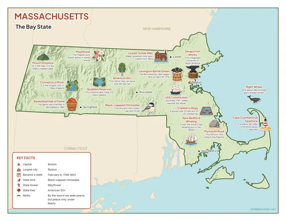
Color
The full-color map, for a wall display or a color printer.

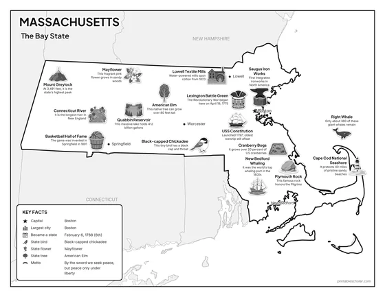
Black and white
The same map with no color or shading. Prints cleanly on a classroom printer and saves ink.

What is on the Massachusetts map
Every picture sits at its real location in Massachusetts, with a one-line fact beside it. Boston, the capital, is marked with a star.
Landmarks and natural places
- Mount Greylock: At 3,491 feet, it is the state’s highest peak.
- Connecticut River: It is the longest river in New England.
- Quabbin Reservoir: This massive lake holds 412 billion gallons.
- Cape Cod National Seashore: It protects 40 miles of pristine sandy beaches.
- Plymouth Rock: This famous rock honors the Pilgrims.
- Lexington Battle Green: The Revolutionary War began here on April 19, 1775.
- Basketball Hall of Fame: The game was invented in Springfield in 1891.
- USS Constitution: Launched 1797; oldest warship still afloat.
- Saugus Iron Works: First integrated ironworks in North America.
What Massachusetts makes and grows
- Cranberry Bogs: It grows over 20 percent of US cranberries.
- New Bedford Whaling: It was the world’s top whaling port in the 1800s.
- Lowell Textile Mills: Water-powered mills spun cotton from 1823.
State symbols
- Mayflower: This fragrant pink flower grows in sandy woods.
- Black-capped Chickadee: This tiny bird has a black cap and throat.
- American Elm: This native tree can grow over 80 feet tall.
- Right Whale: Only about 380 of these giant whales remain.
Massachusetts key facts
From the box on the map
- Nickname
- The Bay State
- Capital
- Boston
- Largest city
- Boston
- Became a state
- February 6, 1788 (6th)
- State bird
- Black-capped chickadee
- State flower
- Mayflower
- State tree
- American Elm
- Motto
- By the sword we seek peace, but peace only under liberty
Cities shown
- Boston (capital)
- Worcester
- Springfield
- Lowell
- New Bedford
The outline, rivers and cities are drawn from map data. Pictures of crops and industries are placed in a part of the state where each is typical.