Maine Landmarks Map
A free printable illustrated map of Maine for kids. It shows 7 landmarks and natural places and 4 industries where they really are, along with the state symbols, 6 cities and a box of key facts. It comes in color and in ink-saving black and white, sized for US Letter paper.
downloadColor PDF downloadBlack and white PDF
Choose your version
Color or black and white.
Both are free, sized for US Letter paper, and come as a PDF to print or a PNG image for slides.
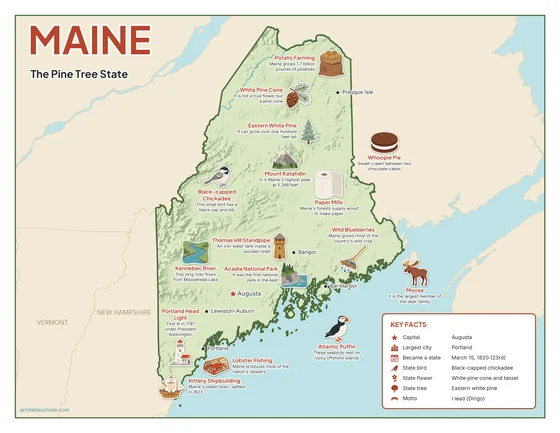
Color
The full-color map, for a wall display or a color printer.

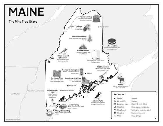
Black and white
The same map with no color or shading. Prints cleanly on a classroom printer and saves ink.

What is on the Maine map
Every picture sits at its real location in Maine, with a one-line fact beside it. Augusta, the capital, is marked with a star.
Landmarks and natural places
- Mount Katahdin: It is Maine’s highest peak at 5,268 feet.
- Acadia National Park: It was the first national park in the east.
- Kennebec River: This long river flows from Moosehead Lake.
- Atlantic Puffin: These seabirds nest on rocky offshore islands.
- Portland Head Light: First lit in 1791 under President Washington.
- Kittery Shipbuilding: Maine’s oldest town, settled in 1623.
- Thomas Hill Standpipe: An iron water tank inside a wooden shell.
What Maine makes and grows
- Lobster Fishing: Maine produces most of the nation’s lobsters.
- Wild Blueberries: Maine grows most of the country’s wild crop.
- Potato Farming: Maine grows 1.7 billion pounds of potatoes.
- Paper Mills: Maine’s forests supply wood to make paper.
State symbols
- Black-capped Chickadee: This small bird has a black cap and bib.
- White Pine Cone: It is not a true flower but a pine cone.
- Eastern White Pine: It can grow over one hundred feet tall.
- Moose: It is the largest member of the deer family.
- Whoopie Pie: Sweet cream between two chocolate cakes.
Maine key facts
From the box on the map
- Nickname
- The Pine Tree State
- Capital
- Augusta
- Largest city
- Portland
- Became a state
- March 15, 1820 (23rd)
- State bird
- Black-capped chickadee
- State flower
- White pine cone and tassel
- State tree
- Eastern white pine
- Motto
- I lead (Dirigo)
Cities shown
- Augusta (capital)
- Portland
- Lewiston-Auburn
- Bangor
- Presque Isle
- Bar Harbor
The outline, rivers and cities are drawn from map data. Pictures of crops and industries are placed in a part of the state where each is typical.