Kentucky Landmarks Map
A free printable illustrated map of Kentucky for kids. It shows 8 landmarks and natural places and 4 industries where they really are, along with the state symbols, 6 cities and a box of key facts. It comes in color and in ink-saving black and white, sized for US Letter paper.
downloadColor PDF downloadBlack and white PDF
Choose your version
Color or black and white.
Both are free, sized for US Letter paper, and come as a PDF to print or a PNG image for slides.
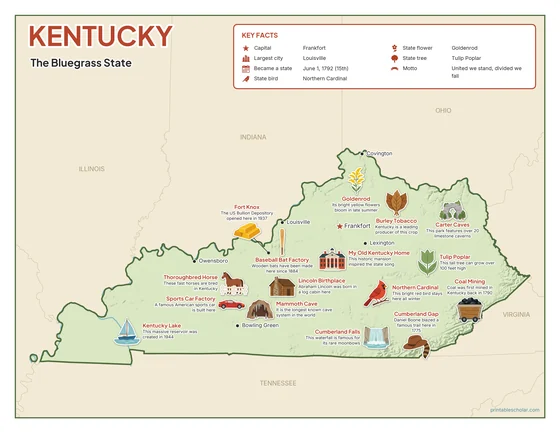
Color
The full-color map, for a wall display or a color printer.

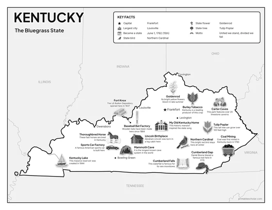
Black and white
The same map with no color or shading. Prints cleanly on a classroom printer and saves ink.

What is on the Kentucky map
Every picture sits at its real location in Kentucky, with a one-line fact beside it. Frankfort, the capital, is marked with a star.
Landmarks and natural places
- Mammoth Cave: It is the longest known cave system in the world.
- Cumberland Falls: This waterfall is famous for its rare moonbows.
- Kentucky Lake: This massive reservoir was created in 1944.
- Carter Caves: This park features over 20 limestone caverns.
- Cumberland Gap: Daniel Boone blazed a famous trail here in 1775.
- Lincoln Birthplace: Abraham Lincoln was born in a log cabin here.
- Fort Knox: The US Bullion Depository opened here in 1937.
- My Old Kentucky Home: This historic mansion inspired the state song.
What Kentucky makes and grows
- Coal Mining: Coal was first mined in Kentucky back in 1790.
- Sports Car Factory: A famous American sports car is built here.
- Burley Tobacco: Kentucky is a leading producer of this crop.
- Baseball Bat Factory: Wooden bats have been made here since 1884.
State symbols
- Northern Cardinal: This bright red bird stays here all winter.
- Goldenrod: Its bright yellow flowers bloom in late summer.
- Tulip Poplar: This tall tree can grow over 100 feet high.
- Thoroughbred Horse: These fast horses are bred in Kentucky.
Kentucky key facts
From the box on the map
- Nickname
- The Bluegrass State
- Capital
- Frankfort
- Largest city
- Louisville
- Became a state
- June 1, 1792 (15th)
- State bird
- Northern Cardinal
- State flower
- Goldenrod
- State tree
- Tulip Poplar
- Motto
- United we stand, divided we fall
Cities shown
- Frankfort (capital)
- Louisville
- Lexington
- Bowling Green
- Owensboro
- Covington
The outline, rivers and cities are drawn from map data. Pictures of crops and industries are placed in a part of the state where each is typical.