Idaho Landmarks Map
A free printable illustrated map of Idaho for kids. It shows 7 landmarks and natural places and 4 industries where they really are, along with the state symbols, 6 cities and a box of key facts. It comes in color and in ink-saving black and white, sized for US Letter paper.
downloadColor PDF downloadBlack and white PDF
Choose your version
Color or black and white.
Both are free, sized for US Letter paper, and come as a PDF to print or a PNG image for slides.
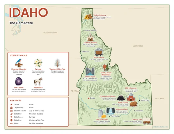
Color
The full-color map, for a wall display or a color printer.

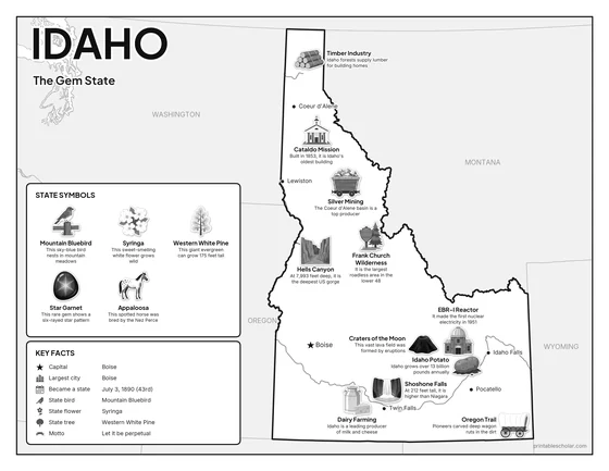
Black and white
The same map with no color or shading. Prints cleanly on a classroom printer and saves ink.

What is on the Idaho map
Every picture sits at its real location in Idaho, with a one-line fact beside it. Boise, the capital, is marked with a star.
Landmarks and natural places
- Frank Church Wilderness: It is the largest roadless area in the lower 48.
- Hells Canyon: At 7,993 feet deep, it is the deepest US gorge.
- Shoshone Falls: At 212 feet tall, it is higher than Niagara.
- Craters of the Moon: This vast lava field was formed by eruptions.
- Cataldo Mission: Built in 1853, it is Idaho’s oldest building.
- Oregon Trail: Pioneers carved deep wagon ruts in the dirt.
- EBR-I Reactor: It made the first nuclear electricity in 1951.
What Idaho makes and grows
- Idaho Potato: Idaho grows over 13 billion pounds annually.
- Silver Mining: The Coeur d’Alene basin is a top producer.
- Timber Industry: Idaho forests supply lumber for building homes.
- Dairy Farming: Idaho is a leading producer of milk and cheese.
State symbols
- Mountain Bluebird: This sky-blue bird nests in mountain meadows.
- Syringa: This sweet-smelling white flower grows wild.
- Western White Pine: This giant evergreen can grow 175 feet tall.
- Star Garnet: This rare gem shows a six-rayed star pattern.
- Appaloosa: This spotted horse was bred by the Nez Perce.
Idaho key facts
From the box on the map
- Nickname
- The Gem State
- Capital
- Boise
- Largest city
- Boise
- Became a state
- July 3, 1890 (43rd)
- State bird
- Mountain Bluebird
- State flower
- Syringa
- State tree
- Western White Pine
- Motto
- Let it be perpetual
Cities shown
- Boise (capital)
- Coeur d’Alene
- Lewiston
- Twin Falls
- Pocatello
- Idaho Falls
The outline, rivers and cities are drawn from map data. Pictures of crops and industries are placed in a part of the state where each is typical.