Georgia Landmarks Map
A free printable illustrated map of Georgia for kids. It shows 8 landmarks and natural places and 4 industries where they really are, along with the state symbols, 5 cities and a box of key facts. It comes in color and in ink-saving black and white, sized for US Letter paper.
downloadColor PDF downloadBlack and white PDF
Choose your version
Color or black and white.
Both are free, sized for US Letter paper, and come as a PDF to print or a PNG image for slides.
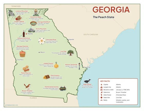
Color
The full-color map, for a wall display or a color printer.

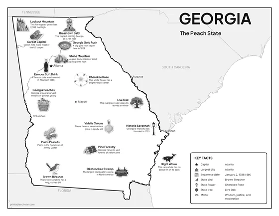
Black and white
The same map with no color or shading. Prints cleanly on a classroom printer and saves ink.

What is on the Georgia map
Every picture sits at its real location in Georgia, with a one-line fact beside it. Atlanta, the capital, is marked with a star.
Landmarks and natural places
- Lookout Mountain: This flat-topped peak rises 2,392 feet high.
- Brasstown Bald: The highest point in Georgia at 4,784 feet.
- Georgia Gold Rush: A big gold rush began here in 1829.
- Stone Mountain: A giant dome made of solid gray granite rock.
- Famous Soft Drink: A famous cola was invented in Atlanta in 1886.
- Plains Peanuts: Plains is the hometown of Jimmy Carter.
- Okefenokee Swamp: The largest blackwater swamp in North America.
- Historic Savannah: Georgia’s first city was founded in 1733.
What Georgia makes and grows
- Carpet Capital: Dalton mills make most of the US carpet.
- Georgia Peaches: Georgia growers harvest millions of pounds yearly.
- Vidalia Onions: These famous sweet onions grow in sandy soil.
- Pine Forestry: Georgia harvests vast forests of yellow pine.
State symbols
- Cherokee Rose: This white flower has a bright yellow center.
- Brown Thrasher: This brown songbird has a long, curved bill.
- Live Oak: This evergreen oak keeps its leaves all winter.
- Right Whale: This rare whale has no dorsal fin on its back.
Georgia key facts
From the box on the map
- Nickname
- The Peach State
- Capital
- Atlanta
- Largest city
- Atlanta
- Became a state
- January 2, 1788 (4th)
- State bird
- Brown Thrasher
- State flower
- Cherokee Rose
- State tree
- Live Oak
- Motto
- Wisdom, justice, and moderation
Cities shown
- Atlanta (capital)
- Savannah
- Columbus
- Augusta
- Macon
The outline, rivers and cities are drawn from map data. Pictures of crops and industries are placed in a part of the state where each is typical.