Florida Landmarks Map
A free printable illustrated map of Florida for kids. It shows 7 landmarks and natural places and 4 industries where they really are, along with the state symbols, 6 cities and a box of key facts. It comes in color and in ink-saving black and white, sized for US Letter paper.
downloadColor PDF downloadBlack and white PDF
Choose your version
Color or black and white.
Both are free, sized for US Letter paper, and come as a PDF to print or a PNG image for slides.
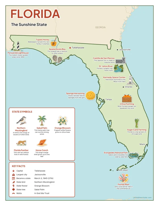
Color
The full-color map, for a wall display or a color printer.

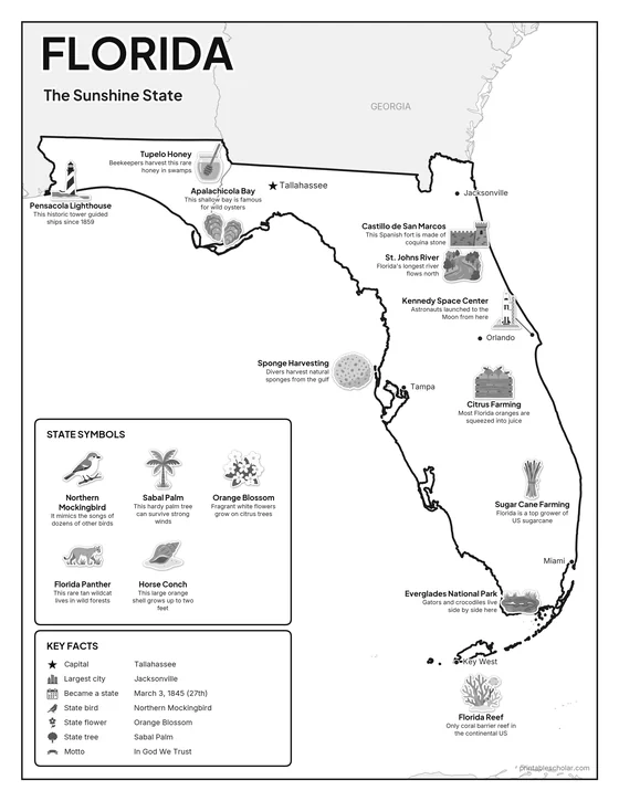
Black and white
The same map with no color or shading. Prints cleanly on a classroom printer and saves ink.

What is on the Florida map
Every picture sits at its real location in Florida, with a one-line fact beside it. Tallahassee, the capital, is marked with a star.
Landmarks and natural places
- Castillo de San Marcos: This Spanish fort is made of coquina stone.
- St. Johns River: Florida’s longest river flows north.
- Kennedy Space Center: Astronauts launched to the Moon from here.
- Everglades National Park: Gators and crocodiles live side by side here.
- Florida Reef: Only coral barrier reef in the continental US.
- Pensacola Lighthouse: This historic tower guided ships since 1859.
- Apalachicola Bay: This shallow bay is famous for wild oysters.
What Florida makes and grows
- Citrus Farming: Most Florida oranges are squeezed into juice.
- Sponge Harvesting: Divers harvest natural sponges from the gulf.
- Sugar Cane Farming: Florida is a top grower of US sugarcane.
- Tupelo Honey: Beekeepers harvest this rare honey in swamps.
State symbols
- Northern Mockingbird: It mimics the songs of dozens of other birds.
- Sabal Palm: This hardy palm tree can survive strong winds.
- Orange Blossom: Fragrant white flowers grow on citrus trees.
- Florida Panther: This rare tan wildcat lives in wild forests.
- Horse Conch: This large orange shell grows up to two feet.
Florida key facts
From the box on the map
- Nickname
- The Sunshine State
- Capital
- Tallahassee
- Largest city
- Jacksonville
- Became a state
- March 3, 1845 (27th)
- State bird
- Northern Mockingbird
- State flower
- Orange Blossom
- State tree
- Sabal Palm
- Motto
- In God We Trust
Cities shown
- Tallahassee (capital)
- Jacksonville
- Miami
- Tampa
- Orlando
- Key West
The outline, rivers and cities are drawn from map data. Pictures of crops and industries are placed in a part of the state where each is typical.