Colorado Landmarks Map
A free printable illustrated map of Colorado for kids. It shows 7 landmarks and natural places and 4 industries where they really are, along with the state symbols, 6 cities and a box of key facts. It comes in color and in ink-saving black and white, sized for US Letter paper.
downloadColor PDF downloadBlack and white PDF
Choose your version
Color or black and white.
Both are free, sized for US Letter paper, and come as a PDF to print or a PNG image for slides.
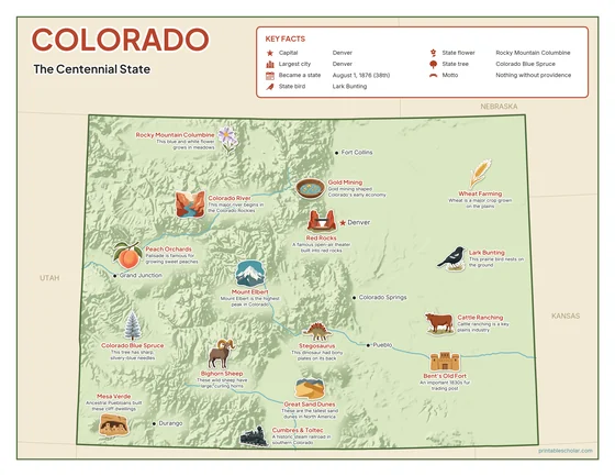
Color
The full-color map, for a wall display or a color printer.

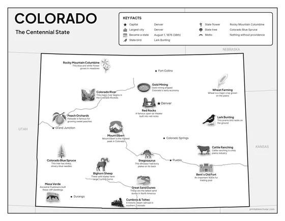
Black and white
The same map with no color or shading. Prints cleanly on a classroom printer and saves ink.

What is on the Colorado map
Every picture sits at its real location in Colorado, with a one-line fact beside it. Denver, the capital, is marked with a star.
Landmarks and natural places
- Mount Elbert: Mount Elbert is the highest peak in Colorado.
- Great Sand Dunes: These are the tallest sand dunes in North America.
- Colorado River: This major river begins in the Colorado Rockies.
- Mesa Verde: Ancestral Puebloans built these cliff dwellings.
- Bent’s Old Fort: An important 1830s fur trading post.
- Red Rocks: A famous open-air theater built into red rocks.
- Cumbres & Toltec: A historic steam railroad in southern Colorado.
What Colorado makes and grows
- Wheat Farming: Wheat is a major crop grown on the plains.
- Gold Mining: Gold mining shaped Colorado’s early economy.
- Peach Orchards: Palisade is famous for growing sweet peaches.
- Cattle Ranching: Cattle ranching is a key plains industry.
State symbols
- Lark Bunting: This prairie bird nests on the ground.
- Rocky Mountain Columbine: This blue and white flower grows in meadows.
- Colorado Blue Spruce: This tree has sharp, silvery-blue needles.
- Bighorn Sheep: These wild sheep have large, curling horns.
- Stegosaurus: This dinosaur had bony plates on its back.
Colorado key facts
From the box on the map
- Nickname
- The Centennial State
- Capital
- Denver
- Largest city
- Denver
- Became a state
- August 1, 1876 (38th)
- State bird
- Lark Bunting
- State flower
- Rocky Mountain Columbine
- State tree
- Colorado Blue Spruce
- Motto
- Nothing without providence
Cities shown
- Denver (capital)
- Colorado Springs
- Pueblo
- Fort Collins
- Grand Junction
- Durango
The outline, rivers and cities are drawn from map data. Pictures of crops and industries are placed in a part of the state where each is typical.