Alabama Landmarks Map
A free printable illustrated map of Alabama for kids. It shows 8 landmarks and natural places and 3 industries where they really are, along with the state symbols, 6 cities and a box of key facts. It comes in color and in ink-saving black and white, sized for US Letter paper.
downloadColor PDF downloadBlack and white PDF
Choose your version
Color or black and white.
Both are free, sized for US Letter paper, and come as a PDF to print or a PNG image for slides.
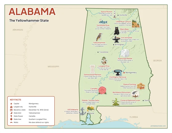
Color
The full-color map, for a wall display or a color printer.

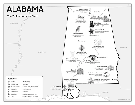
Black and white
The same map with no color or shading. Prints cleanly on a classroom printer and saves ink.

What is on the Alabama map
Every picture sits at its real location in Alabama, with a one-line fact beside it. Montgomery, the capital, is marked with a star.
Landmarks and natural places
- Little River Canyon: One of the deepest canyon systems in the East.
- Tennessee River: This major river flows across northern Alabama.
- Conecuh National Forest: Protects 84,000 acres of coastal pine woods.
- Mobile-Tensaw Delta: Second largest delta in the lower 48 states.
- Gaineswood Mansion: A grand Greek Revival home built 1843-1861.
- Boll Weevil Monument: Erected in 1919 to honor an agricultural pest.
- USS Alabama: A historic World War II battleship in Mobile.
- Civil Rights Memorial: Honors those who died in the movement.
What Alabama makes and grows
- Space Rocket: Huntsville is known as Rocket City, USA.
- Iron and Steel: Birmingham was a major iron producer by 1900.
- Peanut Farming: Alabama grows over 400 million pounds a year.
State symbols
- Yellowhammer: The only state bird that is a woodpecker.
- Camellia: This winter-blooming flower is from Asia.
- Longleaf Pine: This tree can grow up to 100 feet tall.
- Sylacauga Marble: This pure white marble is the state rock.
- Black Bear: This large mammal can run up to 30 mph.
Alabama key facts
From the box on the map
- Nickname
- The Yellowhammer State
- Capital
- Montgomery
- Largest city
- Huntsville
- Became a state
- December 14, 1819 (22nd)
- State bird
- Yellowhammer
- State flower
- Camellia
- State tree
- Southern Longleaf Pine
- Motto
- We dare defend our rights
Cities shown
- Montgomery (capital)
- Huntsville
- Birmingham
- Mobile
- Tuscaloosa
- Dothan
The outline, rivers and cities are drawn from map data. Pictures of crops and industries are placed in a part of the state where each is typical.