Washington Landmarks Map
A free printable illustrated map of Washington for kids. It shows 7 landmarks and natural places and 4 industries where they really are, along with the state symbols, 6 cities and a box of key facts. It comes in color and in ink-saving black and white, sized for US Letter paper.
downloadColor PDF downloadBlack and white PDF
Choose your version
Color or black and white.
Both are free, sized for US Letter paper, and come as a PDF to print or a PNG image for slides.
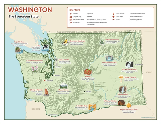
Color
The full-color map, for a wall display or a color printer.

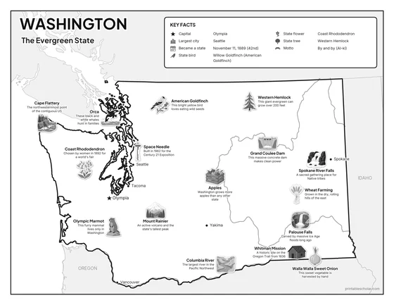
Black and white
The same map with no color or shading. Prints cleanly on a classroom printer and saves ink.

What is on the Washington map
Every picture sits at its real location in Washington, with a one-line fact beside it. Olympia, the capital, is marked with a star.
Landmarks and natural places
- Mount Rainier: An active volcano and the state’s tallest peak.
- Columbia River: The largest river in the Pacific Northwest.
- Palouse Falls: Carved by massive Ice Age floods long ago.
- Space Needle: Built in 1962 for the Century 21 Exposition.
- Cape Flattery: The northwesternmost point of the contiguous US.
- Whitman Mission: A historic site on the Oregon Trail from 1836.
- Spokane River Falls: A sacred gathering place for Native tribes.
What Washington makes and grows
- Apples: Washington grows more apples than any other state.
- Walla Walla Sweet Onion: This sweet vegetable is harvested by hand.
- Wheat Farming: Grown in the dry, rolling hills of the east.
- Grand Coulee Dam: This massive concrete dam makes clean power.
State symbols
- American Goldfinch: This bright yellow bird loves eating wild seeds.
- Coast Rhododendron: Chosen by women in 1892 for a world’s fair.
- Western Hemlock: This giant evergreen can grow over 200 feet.
- Olympic Marmot: This furry mammal lives only in Washington.
- Orca: These black and white whales hunt in families.
Washington key facts
From the box on the map
- Nickname
- The Evergreen State
- Capital
- Olympia
- Largest city
- Seattle
- Became a state
- November 11, 1889 (42nd)
- State bird
- Willow Goldfinch (American Goldfinch)
- State flower
- Coast Rhododendron
- State tree
- Western Hemlock
- Motto
- By and by (Al-ki)
Cities shown
- Olympia (capital)
- Seattle
- Spokane
- Tacoma
- Vancouver
- Yakima
The outline, rivers and cities are drawn from map data. Pictures of crops and industries are placed in a part of the state where each is typical.