Tennessee Landmarks Map
A free printable illustrated map of Tennessee for kids. It shows 8 landmarks and natural places and 4 industries where they really are, along with the state symbols, 5 cities and a box of key facts. It comes in color and in ink-saving black and white, sized for US Letter paper.
downloadColor PDF downloadBlack and white PDF
Choose your version
Color or black and white.
Both are free, sized for US Letter paper, and come as a PDF to print or a PNG image for slides.
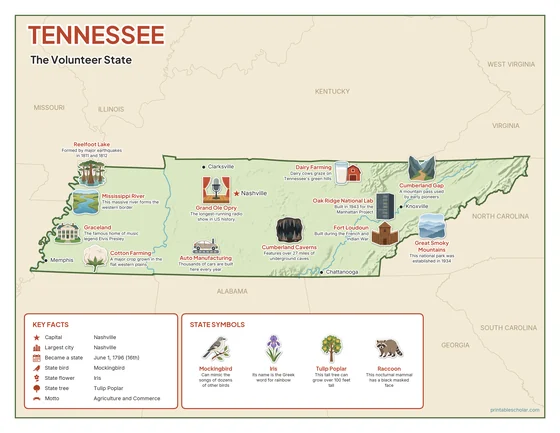
Color
The full-color map, for a wall display or a color printer.

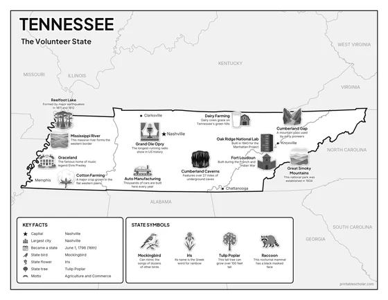
Black and white
The same map with no color or shading. Prints cleanly on a classroom printer and saves ink.

What is on the Tennessee map
Every picture sits at its real location in Tennessee, with a one-line fact beside it. Nashville, the capital, is marked with a star.
Landmarks and natural places
- Great Smoky Mountains: This national park was established in 1934.
- Mississippi River: This massive river forms the western border.
- Reelfoot Lake: Formed by major earthquakes in 1811 and 1812.
- Cumberland Caverns: Features over 27 miles of underground caves.
- Graceland: The famous home of music legend Elvis Presley.
- Grand Ole Opry: The longest-running radio show in US history.
- Fort Loudoun: Built during the French and Indian War.
- Cumberland Gap: A mountain pass used by early pioneers.
What Tennessee makes and grows
- Cotton Farming: A major crop grown in the flat western plains.
- Oak Ridge National Lab: Built in 1943 for the Manhattan Project.
- Auto Manufacturing: Thousands of cars are built here every year.
- Dairy Farming: Dairy cows graze on Tennessee’s green hills.
State symbols
- Mockingbird: Can mimic the songs of dozens of other birds.
- Iris: Its name is the Greek word for rainbow.
- Tulip Poplar: This tall tree can grow over 100 feet tall.
- Raccoon: This nocturnal mammal has a black masked face.
Tennessee key facts
From the box on the map
- Nickname
- The Volunteer State
- Capital
- Nashville
- Largest city
- Nashville
- Became a state
- June 1, 1796 (16th)
- State bird
- Mockingbird
- State flower
- Iris
- State tree
- Tulip Poplar
- Motto
- Agriculture and Commerce
Cities shown
- Nashville (capital)
- Memphis
- Knoxville
- Chattanooga
- Clarksville
The outline, rivers and cities are drawn from map data. Pictures of crops and industries are placed in a part of the state where each is typical.