South Carolina Landmarks Map
A free printable illustrated map of South Carolina for kids. It shows 8 landmarks and natural places and 4 industries where they really are, along with the state symbols, 5 cities and a box of key facts. It comes in color and in ink-saving black and white, sized for US Letter paper.
downloadColor PDF downloadBlack and white PDF
Choose your version
Color or black and white.
Both are free, sized for US Letter paper, and come as a PDF to print or a PNG image for slides.
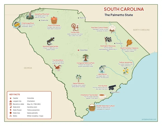
Color
The full-color map, for a wall display or a color printer.

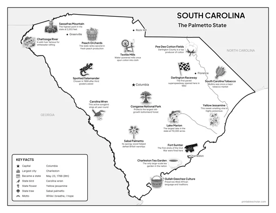
Black and white
The same map with no color or shading. Prints cleanly on a classroom printer and saves ink.

What is on the South Carolina map
Every picture sits at its real location in South Carolina, with a one-line fact beside it. Columbia, the capital, is marked with a star.
Landmarks and natural places
- Sassafras Mountain: The highest point in the state at 3,553 feet.
- Chattooga River: A wild river famous for whitewater rafting.
- Congaree National Park: Protects the largest old-growth bottomland forest.
- Lake Marion: The largest lake in the state at 110,000 acres.
- Fort Sumter: The first shots of the Civil War were fired here.
- Darlington Raceway: The first paved superspeedway opened here in 1950.
- Gullah Geechee Culture: Preserves West African language and traditions.
- South Carolina Tobacco: Mullins was once a major tobacco market.
What South Carolina makes and grows
- Peach Orchards: The state ranks second in fresh peach production.
- Textile Mills: Water-powered mills once spun cotton into cloth.
- Pee Dee Cotton Fields: Darlington County is a top producer of cotton.
- Charleston Tea Garden: The only large-scale tea garden in the nation.
State symbols
- Carolina Wren: This active songbird sings all year round.
- Yellow Jessamine: This sweet-smelling vine is highly poisonous.
- Sabal Palmetto: Its spongy wood helped defeat British warships.
- Spotted Salamander: Chosen in 1999 after third graders asked.
South Carolina key facts
From the box on the map
- Nickname
- The Palmetto State
- Capital
- Columbia
- Largest city
- Charleston
- Became a state
- May 23, 1788 (8th)
- State bird
- Carolina wren
- State flower
- Yellow jessamine
- State tree
- Sabal palmetto
- Motto
- While I breathe, I hope
Cities shown
- Columbia (capital)
- Charleston
- Greenville
- Rock Hill
- Florence
The outline, rivers and cities are drawn from map data. Pictures of crops and industries are placed in a part of the state where each is typical.