North Dakota Landmarks Map
A free printable illustrated map of North Dakota for kids. It shows 8 landmarks and natural places and 4 industries where they really are, along with the state symbols, 6 cities and a box of key facts. It comes in color and in ink-saving black and white, sized for US Letter paper.
downloadColor PDF downloadBlack and white PDF
Choose your version
Color or black and white.
Both are free, sized for US Letter paper, and come as a PDF to print or a PNG image for slides.
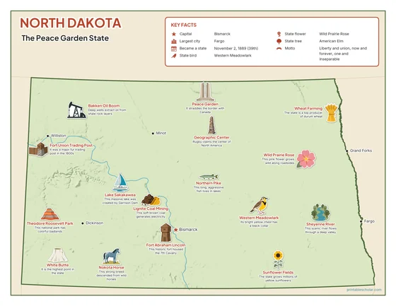
Color
The full-color map, for a wall display or a color printer.

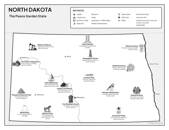
Black and white
The same map with no color or shading. Prints cleanly on a classroom printer and saves ink.

What is on the North Dakota map
Every picture sits at its real location in North Dakota, with a one-line fact beside it. Bismarck, the capital, is marked with a star.
Landmarks and natural places
- Theodore Roosevelt Park: This national park has colorful badlands.
- Lake Sakakawea: This massive lake was created by Garrison Dam.
- White Butte: It is the highest point in the state.
- Sheyenne River: This scenic river flows through a deep valley.
- Peace Garden: It straddles the border with Canada.
- Fort Union Trading Post: It was a major fur trading post in the 1800s.
- Geographic Center: Rugby claims the center of North America.
- Fort Abraham Lincoln: This historic fort housed the 7th Cavalry.
What North Dakota makes and grows
- Wheat Farming: The state is a top producer of durum wheat.
- Sunflower Fields: The state grows millions of yellow sunflowers.
- Bakken Oil Boom: Deep wells extract oil from shale rock layers.
- Lignite Coal Mining: This soft brown coal generates electricity.
State symbols
- Western Meadowlark: Its bright yellow chest has a black collar.
- Wild Prairie Rose: This pink flower grows wild along roadsides.
- Nokota Horse: This strong breed descended from wild horses.
- Northern Pike: This long, aggressive fish lives in lakes.
North Dakota key facts
From the box on the map
- Nickname
- The Peace Garden State
- Capital
- Bismarck
- Largest city
- Fargo
- Became a state
- November 2, 1889 (39th)
- State bird
- Western Meadowlark
- State flower
- Wild Prairie Rose
- State tree
- American Elm
- Motto
- Liberty and union, now and forever, one and inseparable
Cities shown
- Bismarck (capital)
- Fargo
- Grand Forks
- Minot
- Williston
- Dickinson
The outline, rivers and cities are drawn from map data. Pictures of crops and industries are placed in a part of the state where each is typical.