California Landmarks Map
A free printable illustrated map of California for kids. It shows 8 landmarks and natural places and 4 industries where they really are, along with the state symbols, 6 cities and a box of key facts. It comes in color and in ink-saving black and white, sized for US Letter paper.
downloadColor PDF downloadBlack and white PDF
Choose your version
Color or black and white.
Both are free, sized for US Letter paper, and come as a PDF to print or a PNG image for slides.
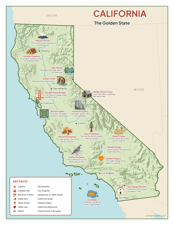
Color
The full-color map, for a wall display or a color printer.

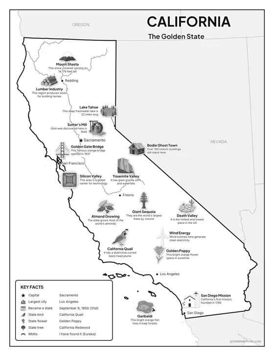
Black and white
The same map with no color or shading. Prints cleanly on a classroom printer and saves ink.

What is on the California map
Every picture sits at its real location in California, with a one-line fact beside it. Sacramento, the capital, is marked with a star.
Landmarks and natural places
- Mount Shasta: This snow-covered volcano is 14,179 feet tall.
- Yosemite Valley: It has giant granite cliffs and waterfalls.
- Lake Tahoe: This deep freshwater lake is 22 miles long.
- Death Valley: It is the hottest and lowest place in the US.
- Golden Gate Bridge: This famous orange bridge opened in 1937.
- San Diego Mission: California’s first mission, founded in 1769.
- Sutter’s Mill: Gold was discovered here in 1848.
- Bodie Ghost Town: Over 100 historic buildings still stand here.
What California makes and grows
- Lumber Industry: This region produces wood for building homes.
- Silicon Valley: This area is a global center for technology.
- Almond Growing: The state grows most of the world’s almonds.
- Wind Energy: Wind turbines here generate clean electricity.
State symbols
- Giant Sequoia: They are the world’s largest trees by volume.
- California Quail: It has a distinctive curved black head plume.
- Golden Poppy: This bright orange flower opens in sunshine.
- Garibaldi: This bright orange fish lives in kelp forests.
California key facts
From the box on the map
- Nickname
- The Golden State
- Capital
- Sacramento
- Largest city
- Los Angeles
- Became a state
- September 9, 1850 (31st)
- State bird
- California Quail
- State flower
- Golden Poppy
- State tree
- California Redwood
- Motto
- I have found it (Eureka)
Cities shown
- Sacramento (capital)
- Los Angeles
- San Francisco
- San Diego
- Fresno
- Redding
The outline, rivers and cities are drawn from map data. Pictures of crops and industries are placed in a part of the state where each is typical.